You are here: Home > Network List > TA - USArray Transportable Network (new EarthScope stations) Stations List
> Station V32A Arapaho, OK, USA > Earthquake Result Viewer
V32A Arapaho, OK, USA - Earthquake Result Viewer
| Earthquake location: |
Eastern Honshu, Japan |
| Earthquake latitude/longitude: |
37.0/140.4 |
| Earthquake time(UTC): |
2011/04/11 (101) 08:16:12 GMT |
| Earthquake Depth: |
11 km |
| Earthquake Magnitude: |
6.4 MB, 6.5 MS, 6.6 MW, 6.6 MW |
| Earthquake Catalog/Contributor: |
WHDF/NEIC |
|
| Network: |
TA USArray Transportable Network (new EarthScope stations) |
| Station: |
V32A Arapaho, OK, USA |
| Lat/Lon: |
35.72 N/99.04 W |
| Elevation: |
533 m |
|
| Distance: |
89.0 deg |
| Az: |
44.494 deg |
| Baz: |
316.41 deg |
| Ray Param: |
0.04215454 |
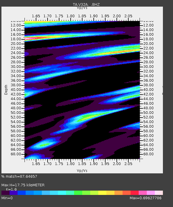
| Estimated Moho Depth: |
17.75 km |
| Estimated Crust Vp/Vs: |
1.60 |
| Assumed Crust Vp: |
6.315 km/s |
| Estimated Crust Vs: |
3.947 km/s |
| Estimated Crust Poisson's Ratio: |
0.18 |
|
| Radial Match: |
87.64657 % |
| Radial Bump: |
400 |
| Transverse Match: |
85.53103 % |
| Transverse Bump: |
400 |
| SOD ConfigId: |
356183 |
| Insert Time: |
2011-09-27 05:51:50.416 +0000 |
| GWidth: |
2.5 |
| Max Bumps: |
400 |
| Tol: |
0.001 |
|
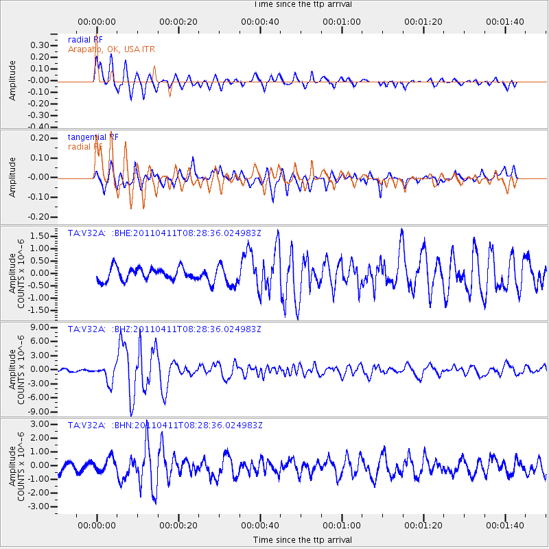
Signal To Noise
| Channel | StoN | STA | LTA |
| TA:V32A: :BHZ:20110411T08:28:36.024983Z | 7.2340345 | 1.9081913E-6 | 2.637797E-7 |
| TA:V32A: :BHN:20110411T08:28:36.024983Z | 1.9637052 | 5.0310774E-7 | 2.562033E-7 |
| TA:V32A: :BHE:20110411T08:28:36.024983Z | 1.6401 | 4.075336E-7 | 2.4848094E-7 |
| Arrivals |
| Ps | 1.7 SECOND |
| PpPs | 7.1 SECOND |
| PsPs/PpSs | 8.9 SECOND |


