You are here: Home > Network List > TA - USArray Transportable Network (new EarthScope stations) Stations List
> Station 434A Burnet, TX, USA > Earthquake Result Viewer
434A Burnet, TX, USA - Earthquake Result Viewer
| Earthquake location: |
Eastern Honshu, Japan |
| Earthquake latitude/longitude: |
37.0/140.4 |
| Earthquake time(UTC): |
2011/04/11 (101) 08:16:12 GMT |
| Earthquake Depth: |
11 km |
| Earthquake Magnitude: |
6.4 MB, 6.5 MS, 6.6 MW, 6.6 MW |
| Earthquake Catalog/Contributor: |
WHDF/NEIC |
|
| Network: |
TA USArray Transportable Network (new EarthScope stations) |
| Station: |
434A Burnet, TX, USA |
| Lat/Lon: |
30.81 N/98.27 W |
| Elevation: |
462 m |
|
| Distance: |
93.0 deg |
| Az: |
47.384 deg |
| Baz: |
316.782 deg |
| Ray Param: |
0.04134299 |
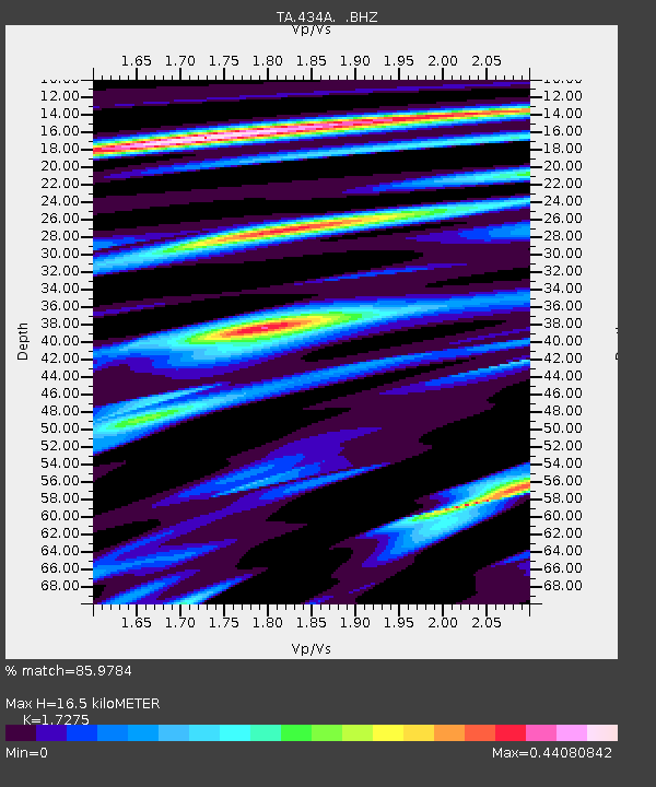
| Estimated Moho Depth: |
16.5 km |
| Estimated Crust Vp/Vs: |
1.73 |
| Assumed Crust Vp: |
6.498 km/s |
| Estimated Crust Vs: |
3.761 km/s |
| Estimated Crust Poisson's Ratio: |
0.25 |
|
| Radial Match: |
85.9784 % |
| Radial Bump: |
400 |
| Transverse Match: |
82.59527 % |
| Transverse Bump: |
400 |
| SOD ConfigId: |
356183 |
| Insert Time: |
2011-09-27 05:54:38.232 +0000 |
| GWidth: |
2.5 |
| Max Bumps: |
400 |
| Tol: |
0.001 |
|
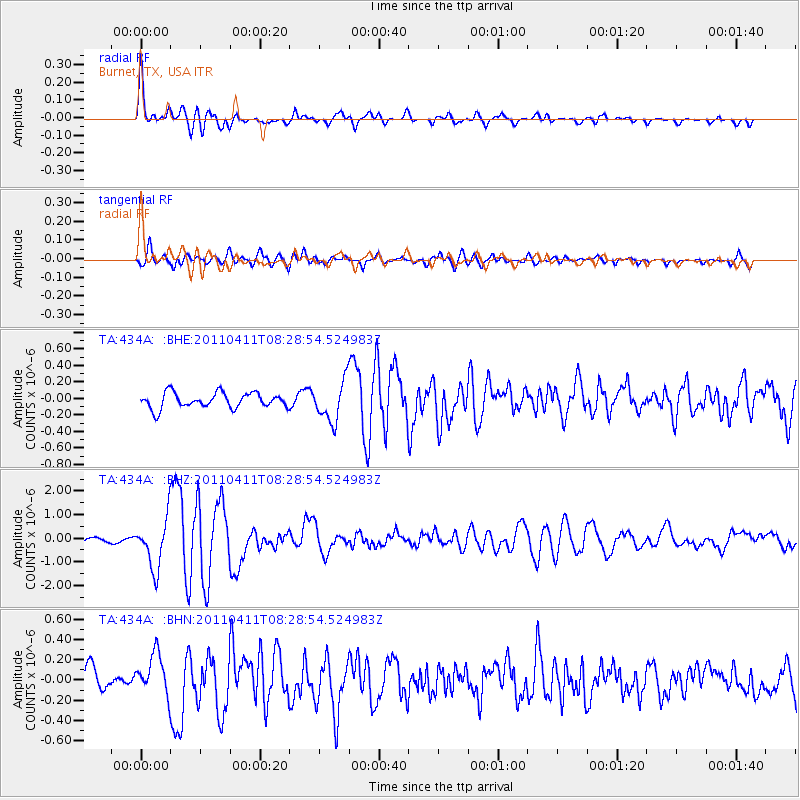
Signal To Noise
| Channel | StoN | STA | LTA |
| TA:434A: :BHZ:20110411T08:28:54.524983Z | 13.736537 | 1.0395019E-6 | 7.567423E-8 |
| TA:434A: :BHN:20110411T08:28:54.524983Z | 1.7833277 | 1.9921313E-7 | 1.1170865E-7 |
| TA:434A: :BHE:20110411T08:28:54.524983Z | 2.651129 | 2.4266794E-7 | 9.15338E-8 |
| Arrivals |
| Ps | 1.9 SECOND |
| PpPs | 6.8 SECOND |
| PsPs/PpSs | 8.7 SECOND |


