You are here: Home > Network List > TA - USArray Transportable Network (new EarthScope stations) Stations List
> Station L02D Cave Junction, OR, USA > Earthquake Result Viewer
L02D Cave Junction, OR, USA - Earthquake Result Viewer
| Earthquake location: |
Eastern Honshu, Japan |
| Earthquake latitude/longitude: |
37.0/140.4 |
| Earthquake time(UTC): |
2011/04/11 (101) 08:16:12 GMT |
| Earthquake Depth: |
11 km |
| Earthquake Magnitude: |
6.4 MB, 6.5 MS, 6.6 MW, 6.6 MW |
| Earthquake Catalog/Contributor: |
WHDF/NEIC |
|
| Network: |
TA USArray Transportable Network (new EarthScope stations) |
| Station: |
L02D Cave Junction, OR, USA |
| Lat/Lon: |
42.16 N/123.60 W |
| Elevation: |
458 m |
|
| Distance: |
70.2 deg |
| Az: |
51.802 deg |
| Baz: |
302.205 deg |
| Ray Param: |
0.055130694 |
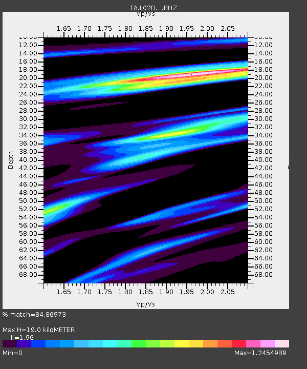
| Estimated Moho Depth: |
19.0 km |
| Estimated Crust Vp/Vs: |
1.96 |
| Assumed Crust Vp: |
6.522 km/s |
| Estimated Crust Vs: |
3.327 km/s |
| Estimated Crust Poisson's Ratio: |
0.32 |
|
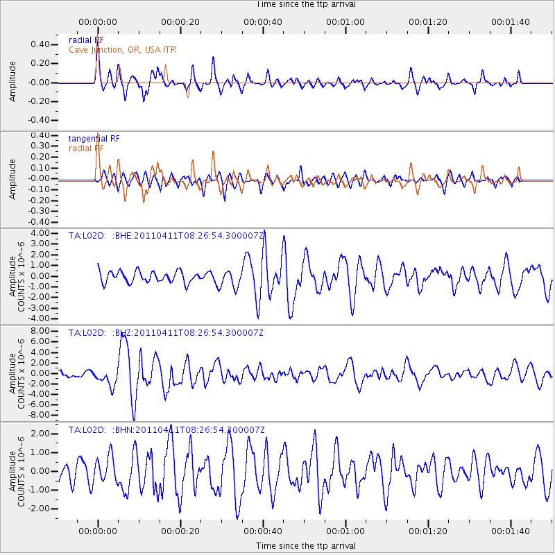
| Radial Match: |
84.86973 % |
| Radial Bump: |
400 |
| Transverse Match: |
69.8329 % |
| Transverse Bump: |
400 |
| SOD ConfigId: |
356183 |
| Insert Time: |
2011-09-27 05:54:46.270 +0000 |
| GWidth: |
2.5 |
| Max Bumps: |
400 |
| Tol: |
0.001 |
|
Signal To Noise
| Channel | StoN | STA | LTA |
| TA:L02D: :BHZ:20110411T08:26:54.300007Z | 2.8363001 | 1.6169575E-6 | 5.7009396E-7 |
| TA:L02D: :BHN:20110411T08:26:54.300007Z | 1.2679856 | 6.947717E-7 | 5.4793344E-7 |
| TA:L02D: :BHE:20110411T08:26:54.300007Z | 1.6066626 | 8.2634364E-7 | 5.14323E-7 |
| Arrivals |
| Ps | 2.9 SECOND |
| PpPs | 8.3 SECOND |
| PsPs/PpSs | 11 SECOND |


