You are here: Home > Network List > TA - USArray Transportable Network (new EarthScope stations) Stations List
> Station 435B Jarrell, TX, USA > Earthquake Result Viewer
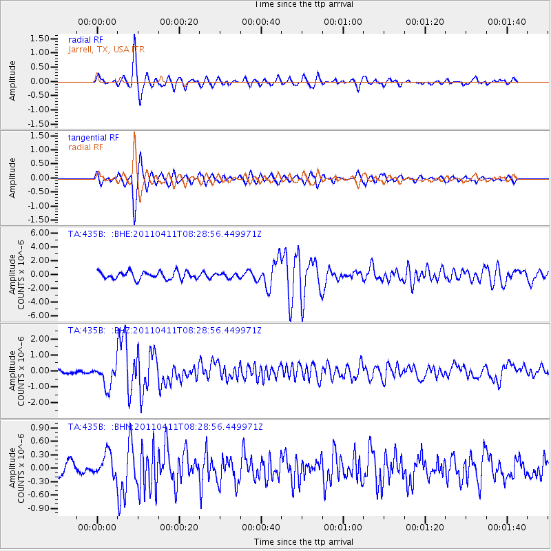
435B Jarrell, TX, USA - Earthquake Result Viewer
*The percent match for this event was below the threshold and hence no stack was calculated.
| Earthquake location: |
Eastern Honshu, Japan |
| Earthquake latitude/longitude: |
37.0/140.4 |
| Earthquake time(UTC): |
2011/04/11 (101) 08:16:12 GMT |
| Earthquake Depth: |
11 km |
| Earthquake Magnitude: |
6.4 MB, 6.5 MS, 6.6 MW, 6.6 MW |
| Earthquake Catalog/Contributor: |
WHDF/NEIC |
|
| Network: |
TA USArray Transportable Network (new EarthScope stations) |
| Station: |
435B Jarrell, TX, USA |
| Lat/Lon: |
30.78 N/97.58 W |
| Elevation: |
248 m |
|
| Distance: |
93.4 deg |
| Az: |
46.975 deg |
| Baz: |
317.153 deg |
| Ray Param: |
$rayparam |
*The percent match for this event was below the threshold and hence was not used in the summary stack. |
|
| Radial Match: |
85.72924 % |
| Radial Bump: |
387 |
| Transverse Match: |
88.054375 % |
| Transverse Bump: |
359 |
| SOD ConfigId: |
356183 |
| Insert Time: |
2011-09-27 06:05:26.396 +0000 |
| GWidth: |
2.5 |
| Max Bumps: |
400 |
| Tol: |
0.001 |
|
Signal To Noise
| Channel | StoN | STA | LTA |
| TA:435B: :BHZ:20110411T08:28:56.449971Z | 5.5542283 | 7.2476934E-7 | 1.3048965E-7 |
| TA:435B: :BHN:20110411T08:28:56.449971Z | 1.7215072 | 2.6360772E-7 | 1.5312612E-7 |
| TA:435B: :BHE:20110411T08:28:56.449971Z | 0.5737842 | 3.130229E-7 | 5.455412E-7 |
| Arrivals |
| Ps | |
| PpPs | |
| PsPs/PpSs | |


