You are here: Home > Network List > AZ - ANZA Regional Network Stations List
> Station SMER AZ.SMER > Earthquake Result Viewer
SMER AZ.SMER - Earthquake Result Viewer
| Earthquake location: |
Salta Province, Argentina |
| Earthquake latitude/longitude: |
-25.0/-63.5 |
| Earthquake time(UTC): |
2005/03/21 (080) 12:23:54 GMT |
| Earthquake Depth: |
579 km |
| Earthquake Magnitude: |
6.1 MB, 6.9 MW, 6.9 MW |
| Earthquake Catalog/Contributor: |
WHDF/NEIC |
|
| Network: |
AZ ANZA Regional Network |
| Station: |
SMER AZ.SMER |
| Lat/Lon: |
33.46 N/117.17 W |
| Elevation: |
355 m |
|
| Distance: |
77.4 deg |
| Az: |
316.333 deg |
| Baz: |
131.45 deg |
| Ray Param: |
0.04854089 |
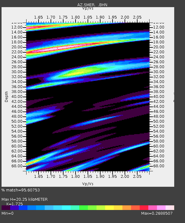
| Estimated Moho Depth: |
20.25 km |
| Estimated Crust Vp/Vs: |
1.73 |
| Assumed Crust Vp: |
6.264 km/s |
| Estimated Crust Vs: |
3.631 km/s |
| Estimated Crust Poisson's Ratio: |
0.25 |
|
| Radial Match: |
95.60753 % |
| Radial Bump: |
239 |
| Transverse Match: |
75.986946 % |
| Transverse Bump: |
400 |
| SOD ConfigId: |
2459 |
| Insert Time: |
2010-02-26 20:44:08.442 +0000 |
| GWidth: |
2.5 |
| Max Bumps: |
400 |
| Tol: |
0.001 |
|
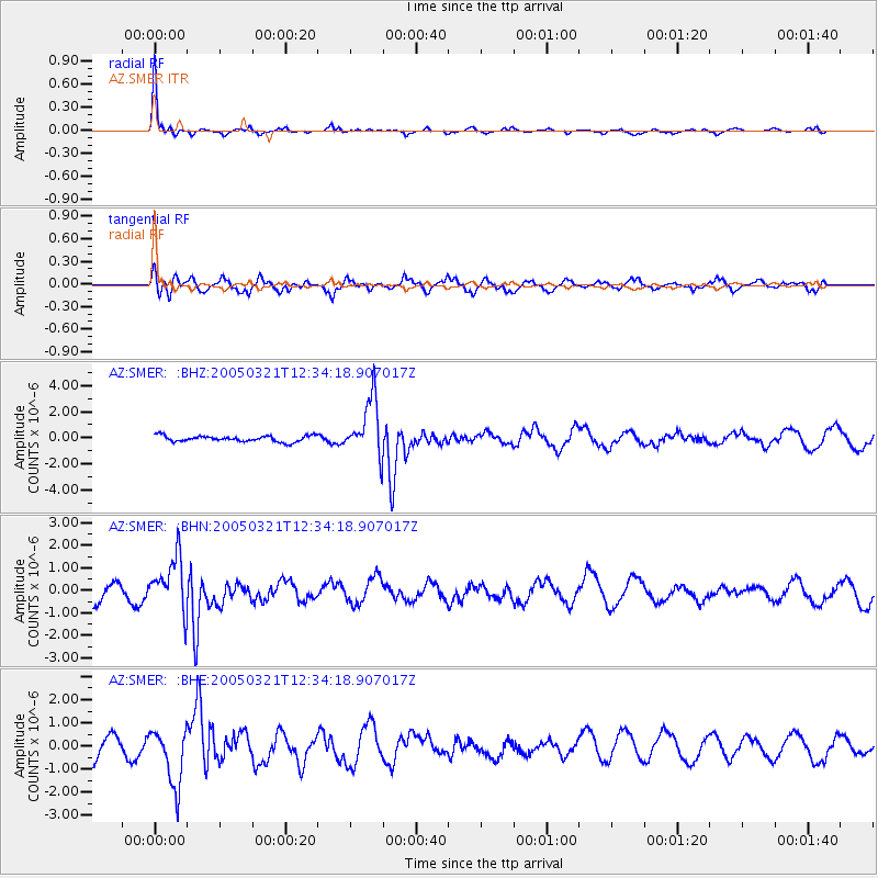
Signal To Noise
| Channel | StoN | STA | LTA |
| AZ:SMER: :BHN:20050321T12:34:18.907017Z | 3.373739 | 1.1682263E-6 | 3.462705E-7 |
| AZ:SMER: :BHE:20050321T12:34:18.907017Z | 2.9190187 | 1.2620293E-6 | 4.323471E-7 |
| AZ:SMER: :BHZ:20050321T12:34:18.907017Z | 9.555047 | 2.216275E-6 | 2.319481E-7 |
| Arrivals |
| Ps | 2.4 SECOND |
| PpPs | 8.6 SECOND |
| PsPs/PpSs | 11 SECOND |


