You are here: Home > Network List > TA - USArray Transportable Network (new EarthScope stations) Stations List
> Station V35A Meyer Ranch, Chandler, OK, USA > Earthquake Result Viewer
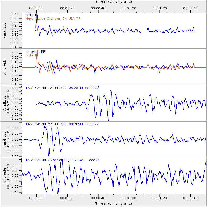
V35A Meyer Ranch, Chandler, OK, USA - Earthquake Result Viewer

| Earthquake location: |
Eastern Honshu, Japan |
| Earthquake latitude/longitude: |
37.0/140.4 |
| Earthquake time(UTC): |
2011/04/11 (101) 08:16:12 GMT |
| Earthquake Depth: |
11 km |
| Earthquake Magnitude: |
6.4 MB, 6.5 MS, 6.6 MW, 6.6 MW |
| Earthquake Catalog/Contributor: |
WHDF/NEIC |
|
| Network: |
TA USArray Transportable Network (new EarthScope stations) |
| Station: |
V35A Meyer Ranch, Chandler, OK, USA |
| Lat/Lon: |
35.76 N/96.84 W |
| Elevation: |
280 m |
|
| Distance: |
90.2 deg |
| Az: |
43.152 deg |
| Baz: |
317.684 deg |
| Ray Param: |
0.041689478 |
| Estimated Moho Depth: |
69.75 km |
| Estimated Crust Vp/Vs: |
1.78 |
| Assumed Crust Vp: |
6.426 km/s |
| Estimated Crust Vs: |
3.61 km/s |
| Estimated Crust Poisson's Ratio: |
0.27 |
|
| Radial Match: |
90.15181 % |
| Radial Bump: |
400 |
| Transverse Match: |
86.68937 % |
| Transverse Bump: |
400 |
| SOD ConfigId: |
356183 |
| Insert Time: |
2011-09-27 06:09:50.287 +0000 |
| GWidth: |
2.5 |
| Max Bumps: |
400 |
| Tol: |
0.001 |
|
Signal To Noise
| Channel | StoN | STA | LTA |
| TA:V35A: :BHZ:20110411T08:28:41.550007Z | 12.232484 | 1.4533042E-6 | 1.1880695E-7 |
| TA:V35A: :BHN:20110411T08:28:41.550007Z | 1.2808344 | 2.5965346E-7 | 2.027221E-7 |
| TA:V35A: :BHE:20110411T08:28:41.550007Z | 2.8867471 | 4.2303498E-7 | 1.4654383E-7 |
| Arrivals |
| Ps | 8.6 SECOND |
| PpPs | 30 SECOND |
| PsPs/PpSs | 38 SECOND |


