You are here: Home > Network List > TA - USArray Transportable Network (new EarthScope stations) Stations List
> Station S34A Willow Spring Farm, Andover, KS, USA > Earthquake Result Viewer
S34A Willow Spring Farm, Andover, KS, USA - Earthquake Result Viewer
| Earthquake location: |
Eastern Honshu, Japan |
| Earthquake latitude/longitude: |
37.0/140.4 |
| Earthquake time(UTC): |
2011/04/11 (101) 08:16:12 GMT |
| Earthquake Depth: |
11 km |
| Earthquake Magnitude: |
6.4 MB, 6.5 MS, 6.6 MW, 6.6 MW |
| Earthquake Catalog/Contributor: |
WHDF/NEIC |
|
| Network: |
TA USArray Transportable Network (new EarthScope stations) |
| Station: |
S34A Willow Spring Farm, Andover, KS, USA |
| Lat/Lon: |
37.70 N/97.11 W |
| Elevation: |
373 m |
|
| Distance: |
88.6 deg |
| Az: |
42.01 deg |
| Baz: |
317.509 deg |
| Ray Param: |
0.042439386 |
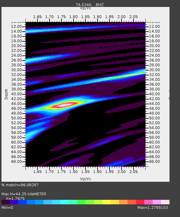
| Estimated Moho Depth: |
44.25 km |
| Estimated Crust Vp/Vs: |
1.77 |
| Assumed Crust Vp: |
6.483 km/s |
| Estimated Crust Vs: |
3.668 km/s |
| Estimated Crust Poisson's Ratio: |
0.26 |
|
| Radial Match: |
96.89297 % |
| Radial Bump: |
336 |
| Transverse Match: |
93.59502 % |
| Transverse Bump: |
400 |
| SOD ConfigId: |
356183 |
| Insert Time: |
2011-09-27 06:10:32.596 +0000 |
| GWidth: |
2.5 |
| Max Bumps: |
400 |
| Tol: |
0.001 |
|

Signal To Noise
| Channel | StoN | STA | LTA |
| TA:S34A: :BHZ:20110411T08:28:34.199971Z | 15.006924 | 2.066077E-6 | 1.3767492E-7 |
| TA:S34A: :BHN:20110411T08:28:34.199971Z | 3.8004444 | 4.3111575E-7 | 1.13438254E-7 |
| TA:S34A: :BHE:20110411T08:28:34.199971Z | 5.0140967 | 5.0181103E-7 | 1.0008005E-7 |
| Arrivals |
| Ps | 5.4 SECOND |
| PpPs | 18 SECOND |
| PsPs/PpSs | 24 SECOND |


