You are here: Home > Network List > TA - USArray Transportable Network (new EarthScope stations) Stations List
> Station Z37A Pogue Cattle Company, Sulphur Springs, TX, USA > Earthquake Result Viewer
Z37A Pogue Cattle Company, Sulphur Springs, TX, USA - Earthquake Result Viewer
| Earthquake location: |
Eastern Honshu, Japan |
| Earthquake latitude/longitude: |
37.0/140.4 |
| Earthquake time(UTC): |
2011/04/11 (101) 08:16:12 GMT |
| Earthquake Depth: |
11 km |
| Earthquake Magnitude: |
6.4 MB, 6.5 MS, 6.6 MW, 6.6 MW |
| Earthquake Catalog/Contributor: |
WHDF/NEIC |
|
| Network: |
TA USArray Transportable Network (new EarthScope stations) |
| Station: |
Z37A Pogue Cattle Company, Sulphur Springs, TX, USA |
| Lat/Lon: |
33.20 N/95.62 W |
| Elevation: |
146 m |
|
| Distance: |
92.8 deg |
| Az: |
44.118 deg |
| Baz: |
318.343 deg |
| Ray Param: |
0.04138982 |
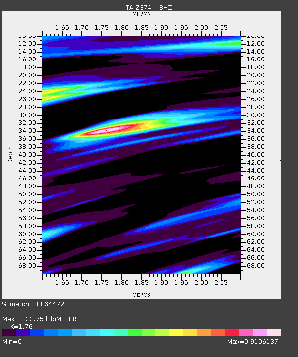
| Estimated Moho Depth: |
33.75 km |
| Estimated Crust Vp/Vs: |
1.76 |
| Assumed Crust Vp: |
6.245 km/s |
| Estimated Crust Vs: |
3.548 km/s |
| Estimated Crust Poisson's Ratio: |
0.26 |
|
| Radial Match: |
83.64472 % |
| Radial Bump: |
400 |
| Transverse Match: |
78.10678 % |
| Transverse Bump: |
400 |
| SOD ConfigId: |
356183 |
| Insert Time: |
2011-09-27 06:15:47.875 +0000 |
| GWidth: |
2.5 |
| Max Bumps: |
400 |
| Tol: |
0.001 |
|
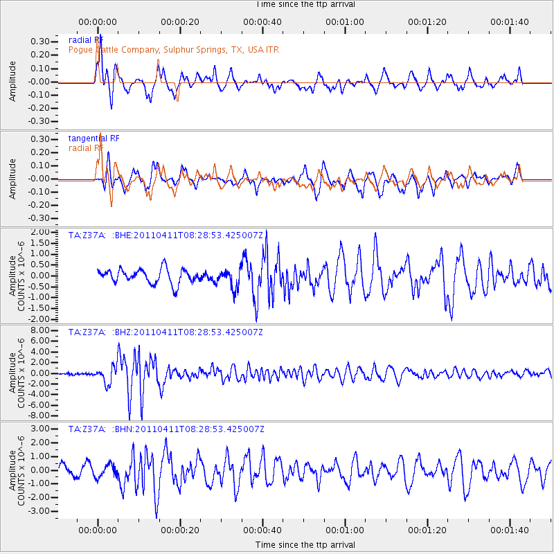
Signal To Noise
| Channel | StoN | STA | LTA |
| TA:Z37A: :BHZ:20110411T08:28:53.425007Z | 5.768197 | 1.6179398E-6 | 2.8049317E-7 |
| TA:Z37A: :BHN:20110411T08:28:53.425007Z | 1.2040496 | 4.4761353E-7 | 3.7175673E-7 |
| TA:Z37A: :BHE:20110411T08:28:53.425007Z | 1.3372936 | 4.3719186E-7 | 3.2692287E-7 |
| Arrivals |
| Ps | 4.2 SECOND |
| PpPs | 15 SECOND |
| PsPs/PpSs | 19 SECOND |


