You are here: Home > Network List > AZ - ANZA Regional Network Stations List
> Station SMER AZ.SMER > Earthquake Result Viewer
SMER AZ.SMER - Earthquake Result Viewer
| Earthquake location: |
New Ireland Region, P.N.G. |
| Earthquake latitude/longitude: |
-4.5/153.5 |
| Earthquake time(UTC): |
2005/09/09 (252) 07:26:43 GMT |
| Earthquake Depth: |
90 km |
| Earthquake Magnitude: |
6.3 MB, 7.7 MW, 7.5 MW |
| Earthquake Catalog/Contributor: |
WHDF/NEIC |
|
| Network: |
AZ ANZA Regional Network |
| Station: |
SMER AZ.SMER |
| Lat/Lon: |
33.46 N/117.17 W |
| Elevation: |
355 m |
|
| Distance: |
91.9 deg |
| Az: |
56.763 deg |
| Baz: |
265.876 deg |
| Ray Param: |
0.041498184 |
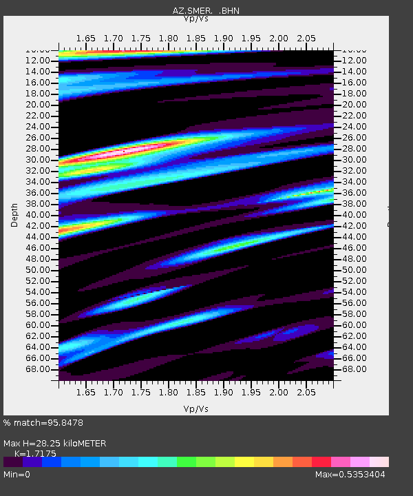
| Estimated Moho Depth: |
28.25 km |
| Estimated Crust Vp/Vs: |
1.72 |
| Assumed Crust Vp: |
6.264 km/s |
| Estimated Crust Vs: |
3.647 km/s |
| Estimated Crust Poisson's Ratio: |
0.24 |
|
| Radial Match: |
95.8478 % |
| Radial Bump: |
400 |
| Transverse Match: |
71.722244 % |
| Transverse Bump: |
400 |
| SOD ConfigId: |
2475 |
| Insert Time: |
2010-02-26 20:44:19.799 +0000 |
| GWidth: |
2.5 |
| Max Bumps: |
400 |
| Tol: |
0.001 |
|
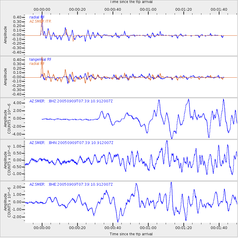
Signal To Noise
| Channel | StoN | STA | LTA |
| AZ:SMER: :BHN:20050909T07:39:10.912007Z | 0.24949224 | 9.6104216E-8 | 3.851992E-7 |
| AZ:SMER: :BHE:20050909T07:39:10.912007Z | 4.1668577 | 3.944891E-7 | 9.4673034E-8 |
| AZ:SMER: :BHZ:20050909T07:39:10.912007Z | 12.613826 | 1.0170443E-6 | 8.062933E-8 |
| Arrivals |
| Ps | 3.3 SECOND |
| PpPs | 12 SECOND |
| PsPs/PpSs | 15 SECOND |


