You are here: Home > Network List > TA - USArray Transportable Network (new EarthScope stations) Stations List
> Station J33A Davis, SD, USA > Earthquake Result Viewer
J33A Davis, SD, USA - Earthquake Result Viewer
| Earthquake location: |
Eastern Honshu, Japan |
| Earthquake latitude/longitude: |
37.0/140.4 |
| Earthquake time(UTC): |
2011/04/11 (101) 08:16:12 GMT |
| Earthquake Depth: |
11 km |
| Earthquake Magnitude: |
6.4 MB, 6.5 MS, 6.6 MW, 6.6 MW |
| Earthquake Catalog/Contributor: |
WHDF/NEIC |
|
| Network: |
TA USArray Transportable Network (new EarthScope stations) |
| Station: |
J33A Davis, SD, USA |
| Lat/Lon: |
43.32 N/96.97 W |
| Elevation: |
400 m |
|
| Distance: |
84.6 deg |
| Az: |
38.127 deg |
| Baz: |
317.373 deg |
| Ray Param: |
0.04538442 |
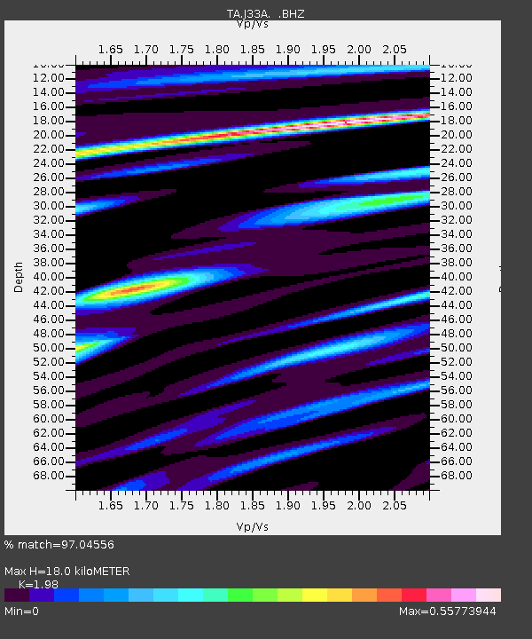
| Estimated Moho Depth: |
18.0 km |
| Estimated Crust Vp/Vs: |
1.98 |
| Assumed Crust Vp: |
6.498 km/s |
| Estimated Crust Vs: |
3.282 km/s |
| Estimated Crust Poisson's Ratio: |
0.33 |
|
| Radial Match: |
97.04556 % |
| Radial Bump: |
380 |
| Transverse Match: |
86.81514 % |
| Transverse Bump: |
400 |
| SOD ConfigId: |
356183 |
| Insert Time: |
2011-09-27 06:31:49.904 +0000 |
| GWidth: |
2.5 |
| Max Bumps: |
400 |
| Tol: |
0.001 |
|

Signal To Noise
| Channel | StoN | STA | LTA |
| TA:J33A: :BHZ:20110411T08:28:14.399983Z | 27.775515 | 3.384859E-6 | 1.2186484E-7 |
| TA:J33A: :BHN:20110411T08:28:14.399983Z | 5.644314 | 8.022657E-7 | 1.4213697E-7 |
| TA:J33A: :BHE:20110411T08:28:14.399983Z | 6.217644 | 8.4170404E-7 | 1.3537347E-7 |
| Arrivals |
| Ps | 2.8 SECOND |
| PpPs | 8.1 SECOND |
| PsPs/PpSs | 11 SECOND |


