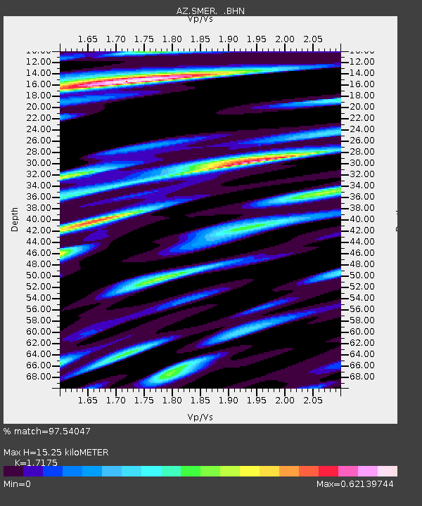
SMER AZ.SMER - Earthquake Result Viewer
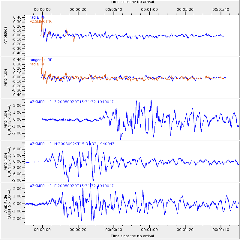
Earthquake location: Kermadec Islands, New Zealand
Earthquake latitude/longitude: -29.8/-177.7
Earthquake time(UTC): 2008/09/29 (273) 15:19:31 GMT
Earthquake Depth: 36 km
Earthquake Magnitude: 6.5 MB, 6.7 MS, 7.0 MW, 7.0 MW
Earthquake Catalog/Contributor: WHDF/NEIC
Network: AZ ANZA Regional Network
Station: SMER AZ.SMER
Lat/Lon: 33.46 N/117.17 W
Elevation: 355 m
Distance: 85.0 deg
Az: 46.925 deg
Baz: 229.447 deg
Ray Param: 0.04501716
Estimated Moho Depth: 15.25 km
Estimated Crust Vp/Vs: 1.72
Assumed Crust Vp: 6.264 km/s
Estimated Crust Vs: 3.647 km/s
Estimated Crust Poisson's Ratio: 0.24
Radial Match: 97.54047 %
Radial Bump: 400
Transverse Match: 93.71348 %
Transverse Bump: 400
SOD ConfigId: 2560
Insert Time: 2010-02-26 20:44:36.756 +0000
GWidth: 2.5
Max Bumps: 400
Tol: 0.001

Signal To Noise

ChannelStoNSTALTA
AZ:SMER: :BHN:20080929T15:31:32.194004Z7.51469047.4515293E-79.915949E-8
AZ:SMER: :BHE:20080929T15:31:32.194004Z1.53907762.1751109E-71.4132561E-7
AZ:SMER: :BHZ:20080929T15:31:32.194004Z2.47171452.2288062E-79.017247E-8
Arrivals
Ps1.8 SECOND
PpPs6.5 SECOND
PsPs/PpSs8.2 SECOND