You are here: Home > Network List > TA - USArray Transportable Network (new EarthScope stations) Stations List
> Station E32A Braaten, Kindred, ND, USA > Earthquake Result Viewer
E32A Braaten, Kindred, ND, USA - Earthquake Result Viewer
| Earthquake location: |
Eastern Honshu, Japan |
| Earthquake latitude/longitude: |
37.0/140.4 |
| Earthquake time(UTC): |
2011/04/11 (101) 08:16:12 GMT |
| Earthquake Depth: |
11 km |
| Earthquake Magnitude: |
6.4 MB, 6.5 MS, 6.6 MW, 6.6 MW |
| Earthquake Catalog/Contributor: |
WHDF/NEIC |
|
| Network: |
TA USArray Transportable Network (new EarthScope stations) |
| Station: |
E32A Braaten, Kindred, ND, USA |
| Lat/Lon: |
46.59 N/97.07 W |
| Elevation: |
297 m |
|
| Distance: |
82.1 deg |
| Az: |
35.942 deg |
| Baz: |
317.047 deg |
| Ray Param: |
0.04710587 |
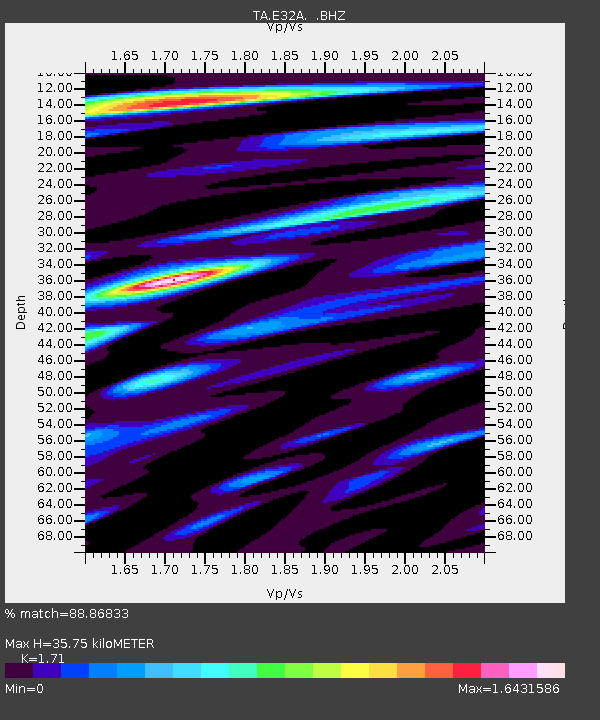
| Estimated Moho Depth: |
35.75 km |
| Estimated Crust Vp/Vs: |
1.71 |
| Assumed Crust Vp: |
6.498 km/s |
| Estimated Crust Vs: |
3.8 km/s |
| Estimated Crust Poisson's Ratio: |
0.24 |
|
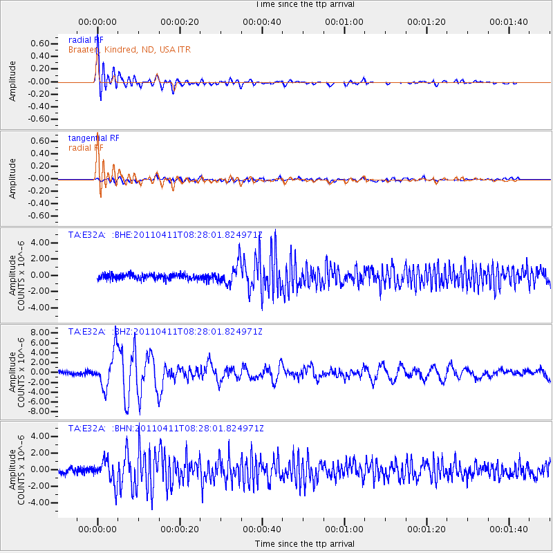
| Radial Match: |
88.86833 % |
| Radial Bump: |
400 |
| Transverse Match: |
60.852875 % |
| Transverse Bump: |
400 |
| SOD ConfigId: |
356183 |
| Insert Time: |
2011-09-27 06:36:44.414 +0000 |
| GWidth: |
2.5 |
| Max Bumps: |
400 |
| Tol: |
0.001 |
|
Signal To Noise
| Channel | StoN | STA | LTA |
| TA:E32A: :BHZ:20110411T08:28:01.824971Z | 11.711456 | 3.6841618E-6 | 3.145776E-7 |
| TA:E32A: :BHN:20110411T08:28:01.824971Z | 4.591456 | 1.4259421E-6 | 3.1056425E-7 |
| TA:E32A: :BHE:20110411T08:28:01.824971Z | 4.2816105 | 1.3394022E-6 | 3.128267E-7 |
| Arrivals |
| Ps | 4.0 SECOND |
| PpPs | 14 SECOND |
| PsPs/PpSs | 19 SECOND |


