You are here: Home > Network List > TA - USArray Transportable Network (new EarthScope stations) Stations List
> Station B32A Ashes, Strandquist, MN, USA > Earthquake Result Viewer
B32A Ashes, Strandquist, MN, USA - Earthquake Result Viewer
| Earthquake location: |
Eastern Honshu, Japan |
| Earthquake latitude/longitude: |
37.0/140.4 |
| Earthquake time(UTC): |
2011/04/11 (101) 08:16:12 GMT |
| Earthquake Depth: |
11 km |
| Earthquake Magnitude: |
6.4 MB, 6.5 MS, 6.6 MW, 6.6 MW |
| Earthquake Catalog/Contributor: |
WHDF/NEIC |
|
| Network: |
TA USArray Transportable Network (new EarthScope stations) |
| Station: |
B32A Ashes, Strandquist, MN, USA |
| Lat/Lon: |
48.40 N/96.54 W |
| Elevation: |
335 m |
|
| Distance: |
81.0 deg |
| Az: |
34.434 deg |
| Baz: |
317.218 deg |
| Ray Param: |
0.047861323 |
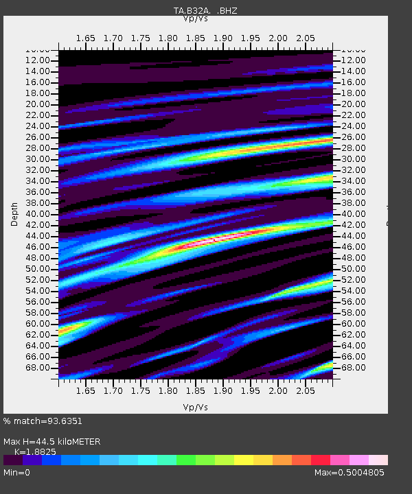
| Estimated Moho Depth: |
44.5 km |
| Estimated Crust Vp/Vs: |
1.88 |
| Assumed Crust Vp: |
6.498 km/s |
| Estimated Crust Vs: |
3.452 km/s |
| Estimated Crust Poisson's Ratio: |
0.30 |
|
| Radial Match: |
93.6351 % |
| Radial Bump: |
400 |
| Transverse Match: |
80.54232 % |
| Transverse Bump: |
400 |
| SOD ConfigId: |
356183 |
| Insert Time: |
2011-09-27 06:38:28.245 +0000 |
| GWidth: |
2.5 |
| Max Bumps: |
400 |
| Tol: |
0.001 |
|
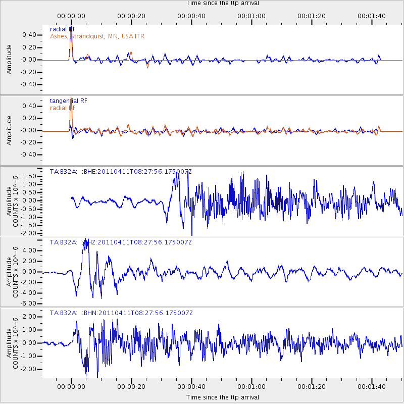
Signal To Noise
| Channel | StoN | STA | LTA |
| TA:B32A: :BHZ:20110411T08:27:56.175007Z | 20.304707 | 2.8520128E-6 | 1.4046067E-7 |
| TA:B32A: :BHN:20110411T08:27:56.175007Z | 12.02585 | 9.475701E-7 | 7.8794436E-8 |
| TA:B32A: :BHE:20110411T08:27:56.175007Z | 4.108759 | 7.0283596E-7 | 1.7105796E-7 |
| Arrivals |
| Ps | 6.2 SECOND |
| PpPs | 19 SECOND |
| PsPs/PpSs | 25 SECOND |


