You are here: Home > Network List > TA - USArray Transportable Network (new EarthScope stations) Stations List
> Station D32A Dogwood Acres, Gardner, ND, USA > Earthquake Result Viewer
D32A Dogwood Acres, Gardner, ND, USA - Earthquake Result Viewer
| Earthquake location: |
Eastern Honshu, Japan |
| Earthquake latitude/longitude: |
37.0/140.4 |
| Earthquake time(UTC): |
2011/04/11 (101) 08:16:12 GMT |
| Earthquake Depth: |
11 km |
| Earthquake Magnitude: |
6.4 MB, 6.5 MS, 6.6 MW, 6.6 MW |
| Earthquake Catalog/Contributor: |
WHDF/NEIC |
|
| Network: |
TA USArray Transportable Network (new EarthScope stations) |
| Station: |
D32A Dogwood Acres, Gardner, ND, USA |
| Lat/Lon: |
47.14 N/97.02 W |
| Elevation: |
280 m |
|
| Distance: |
81.7 deg |
| Az: |
35.541 deg |
| Baz: |
317.029 deg |
| Ray Param: |
0.04736707 |
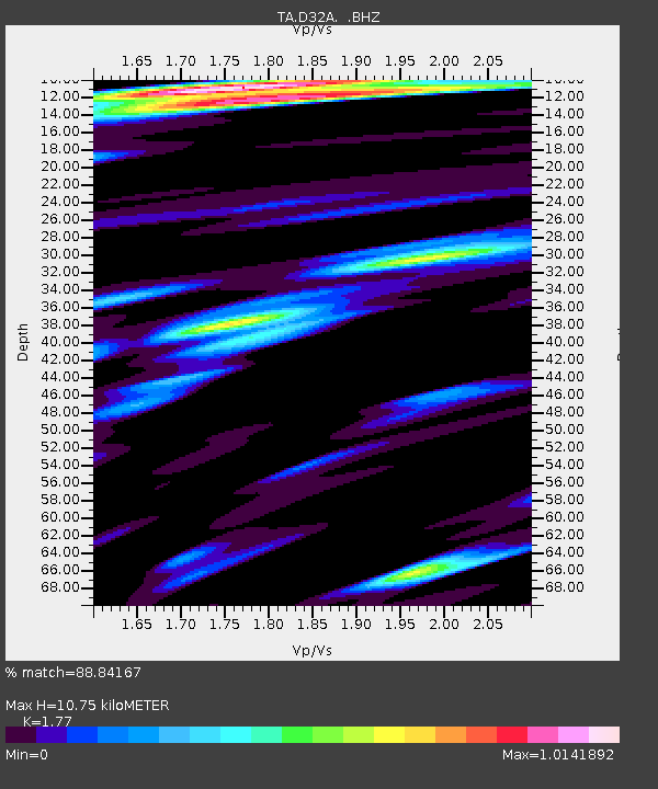
| Estimated Moho Depth: |
10.75 km |
| Estimated Crust Vp/Vs: |
1.77 |
| Assumed Crust Vp: |
6.498 km/s |
| Estimated Crust Vs: |
3.671 km/s |
| Estimated Crust Poisson's Ratio: |
0.27 |
|
| Radial Match: |
88.84167 % |
| Radial Bump: |
400 |
| Transverse Match: |
62.379753 % |
| Transverse Bump: |
400 |
| SOD ConfigId: |
356183 |
| Insert Time: |
2011-09-27 06:39:24.950 +0000 |
| GWidth: |
2.5 |
| Max Bumps: |
400 |
| Tol: |
0.001 |
|
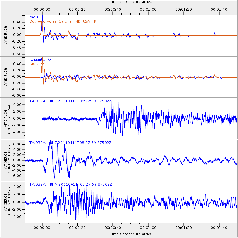
Signal To Noise
| Channel | StoN | STA | LTA |
| TA:D32A: :BHZ:20110411T08:27:59.87502Z | 19.253222 | 3.3388262E-6 | 1.734165E-7 |
| TA:D32A: :BHN:20110411T08:27:59.87502Z | 4.388194 | 9.660378E-7 | 2.2014471E-7 |
| TA:D32A: :BHE:20110411T08:27:59.87502Z | 4.1114464 | 9.293625E-7 | 2.2604272E-7 |
| Arrivals |
| Ps | 1.3 SECOND |
| PpPs | 4.5 SECOND |
| PsPs/PpSs | 5.8 SECOND |


