You are here: Home > Network List > TA - USArray Transportable Network (new EarthScope stations) Stations List
> Station E31A Nome, ND, USA > Earthquake Result Viewer
E31A Nome, ND, USA - Earthquake Result Viewer
| Earthquake location: |
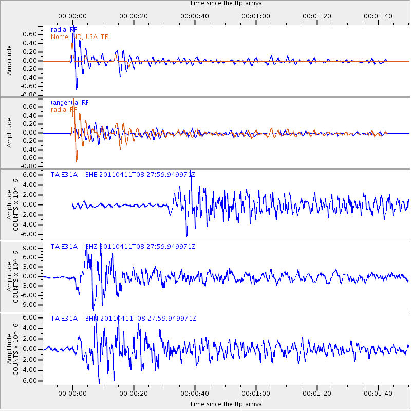
Eastern Honshu, Japan |
| Earthquake latitude/longitude: |
37.0/140.4 |
| Earthquake time(UTC): |
2011/04/11 (101) 08:16:12 GMT |
| Earthquake Depth: |
11 km |
| Earthquake Magnitude: |
6.4 MB, 6.5 MS, 6.6 MW, 6.6 MW |
| Earthquake Catalog/Contributor: |
WHDF/NEIC |
|
| Network: |
TA USArray Transportable Network (new EarthScope stations) |
| Station: |
E31A Nome, ND, USA |
| Lat/Lon: |
46.56 N/97.89 W |
| Elevation: |
427 m |
|
| Distance: |
81.8 deg |
| Az: |
36.381 deg |
| Baz: |
316.516 deg |
| Ray Param: |
0.047359366 |
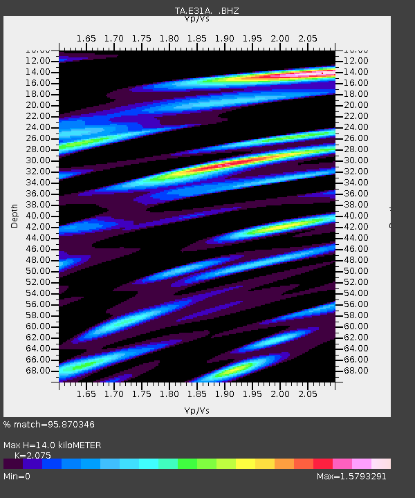
| Estimated Moho Depth: |
14.0 km |
| Estimated Crust Vp/Vs: |
2.08 |
| Assumed Crust Vp: |
6.498 km/s |
| Estimated Crust Vs: |
3.131 km/s |
| Estimated Crust Poisson's Ratio: |
0.35 |
|
| Radial Match: |
95.870346 % |
| Radial Bump: |
400 |
| Transverse Match: |
86.61104 % |
| Transverse Bump: |
400 |
| SOD ConfigId: |
356183 |
| Insert Time: |
2011-09-27 06:40:21.110 +0000 |
| GWidth: |
2.5 |
| Max Bumps: |
400 |
| Tol: |
0.001 |
|
Signal To Noise
| Channel | StoN | STA | LTA |
| TA:E31A: :BHZ:20110411T08:27:59.949971Z | 28.031214 | 3.8096894E-6 | 1.3590883E-7 |
| TA:E31A: :BHN:20110411T08:27:59.949971Z | 5.223618 | 1.3431429E-6 | 2.5712885E-7 |
| TA:E31A: :BHE:20110411T08:27:59.949971Z | 4.33076 | 1.1199451E-6 | 2.5860243E-7 |
| Arrivals |
| Ps | 2.4 SECOND |
| PpPs | 6.5 SECOND |
| PsPs/PpSs | 8.8 SECOND |


