You are here: Home > Network List > TA - USArray Transportable Network (new EarthScope stations) Stations List
> Station E33A Westby DABS, Erhard, MN, USA > Earthquake Result Viewer
E33A Westby DABS, Erhard, MN, USA - Earthquake Result Viewer
| Earthquake location: |
Eastern Honshu, Japan |
| Earthquake latitude/longitude: |
37.0/140.4 |
| Earthquake time(UTC): |
2011/04/11 (101) 08:16:12 GMT |
| Earthquake Depth: |
11 km |
| Earthquake Magnitude: |
6.4 MB, 6.5 MS, 6.6 MW, 6.6 MW |
| Earthquake Catalog/Contributor: |
WHDF/NEIC |
|
| Network: |
TA USArray Transportable Network (new EarthScope stations) |
| Station: |
E33A Westby DABS, Erhard, MN, USA |
| Lat/Lon: |
46.50 N/96.01 W |
| Elevation: |
428 m |
|
| Distance: |
82.7 deg |
| Az: |
35.457 deg |
| Baz: |
317.753 deg |
| Ray Param: |
0.0467153 |
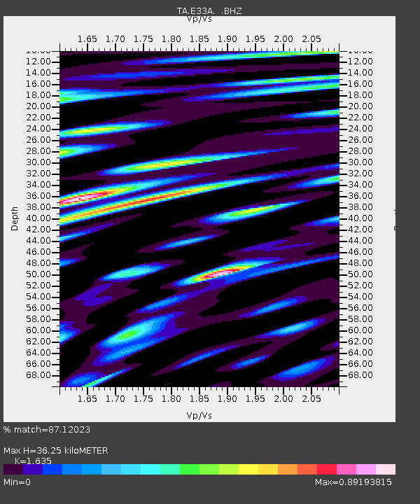
| Estimated Moho Depth: |
36.25 km |
| Estimated Crust Vp/Vs: |
1.63 |
| Assumed Crust Vp: |
6.498 km/s |
| Estimated Crust Vs: |
3.974 km/s |
| Estimated Crust Poisson's Ratio: |
0.20 |
|
| Radial Match: |
87.12023 % |
| Radial Bump: |
400 |
| Transverse Match: |
70.93186 % |
| Transverse Bump: |
400 |
| SOD ConfigId: |
356183 |
| Insert Time: |
2011-09-27 06:40:28.857 +0000 |
| GWidth: |
2.5 |
| Max Bumps: |
400 |
| Tol: |
0.001 |
|
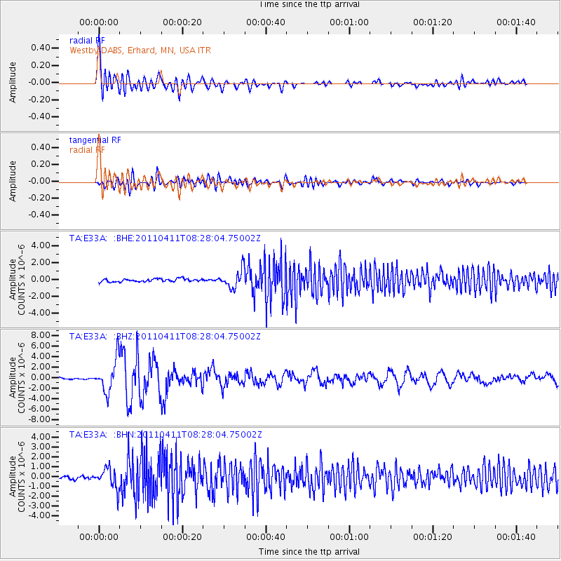
Signal To Noise
| Channel | StoN | STA | LTA |
| TA:E33A: :BHZ:20110411T08:28:04.75002Z | 23.82188 | 3.17177E-6 | 1.3314525E-7 |
| TA:E33A: :BHN:20110411T08:28:04.75002Z | 5.68679 | 1.0412654E-6 | 1.8310249E-7 |
| TA:E33A: :BHE:20110411T08:28:04.75002Z | 6.3320436 | 1.1167131E-6 | 1.7635902E-7 |
| Arrivals |
| Ps | 3.6 SECOND |
| PpPs | 14 SECOND |
| PsPs/PpSs | 18 SECOND |


