You are here: Home > Network List > TA - USArray Transportable Network (new EarthScope stations) Stations List
> Station H31A Wolsey, SD, USA > Earthquake Result Viewer
H31A Wolsey, SD, USA - Earthquake Result Viewer
| Earthquake location: |
Eastern Honshu, Japan |
| Earthquake latitude/longitude: |
37.0/140.4 |
| Earthquake time(UTC): |
2011/04/11 (101) 08:16:12 GMT |
| Earthquake Depth: |
11 km |
| Earthquake Magnitude: |
6.4 MB, 6.5 MS, 6.6 MW, 6.6 MW |
| Earthquake Catalog/Contributor: |
WHDF/NEIC |
|
| Network: |
TA USArray Transportable Network (new EarthScope stations) |
| Station: |
H31A Wolsey, SD, USA |
| Lat/Lon: |
44.48 N/98.48 W |
| Elevation: |
415 m |
|
| Distance: |
83.0 deg |
| Az: |
38.13 deg |
| Baz: |
316.329 deg |
| Ray Param: |
0.04650934 |
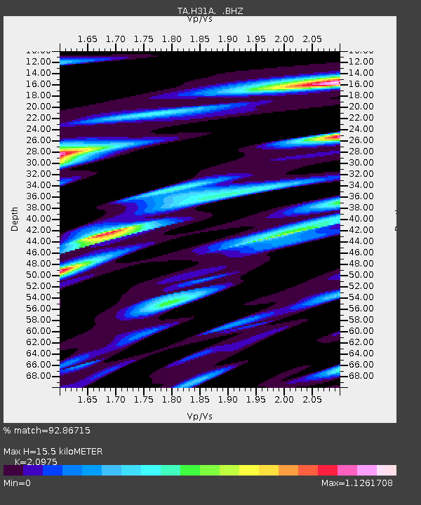
| Estimated Moho Depth: |
15.5 km |
| Estimated Crust Vp/Vs: |
2.10 |
| Assumed Crust Vp: |
6.53 km/s |
| Estimated Crust Vs: |
3.113 km/s |
| Estimated Crust Poisson's Ratio: |
0.35 |
|
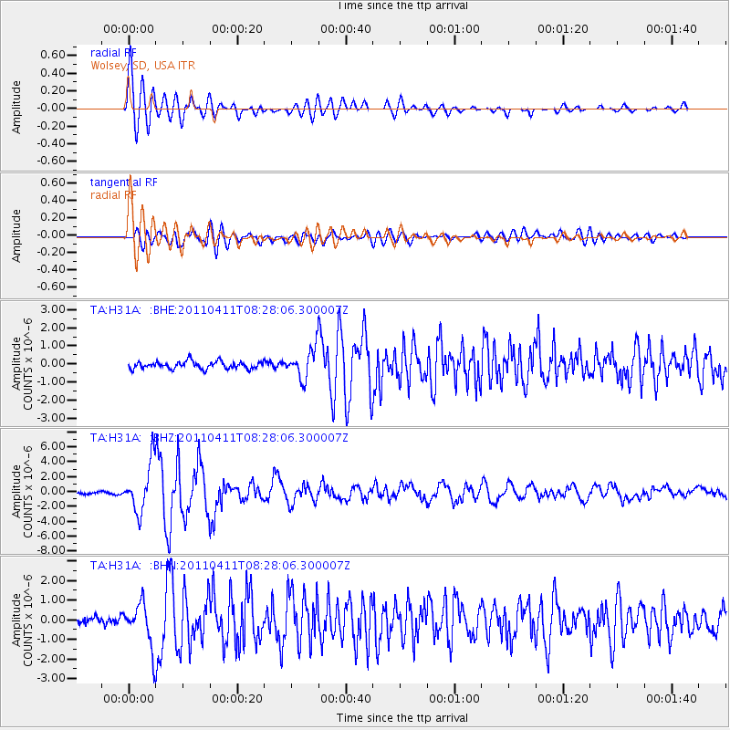
| Radial Match: |
92.86715 % |
| Radial Bump: |
400 |
| Transverse Match: |
80.42211 % |
| Transverse Bump: |
400 |
| SOD ConfigId: |
356183 |
| Insert Time: |
2011-09-27 06:41:51.410 +0000 |
| GWidth: |
2.5 |
| Max Bumps: |
400 |
| Tol: |
0.001 |
|
Signal To Noise
| Channel | StoN | STA | LTA |
| TA:H31A: :BHZ:20110411T08:28:06.300007Z | 29.76689 | 3.2630776E-6 | 1.09621055E-7 |
| TA:H31A: :BHN:20110411T08:28:06.300007Z | 4.26065 | 1.0977191E-6 | 2.576412E-7 |
| TA:H31A: :BHE:20110411T08:28:06.300007Z | 4.0887074 | 8.3084194E-7 | 2.0320405E-7 |
| Arrivals |
| Ps | 2.7 SECOND |
| PpPs | 7.2 SECOND |
| PsPs/PpSs | 9.9 SECOND |


