You are here: Home > Network List > AZ - ANZA Regional Network Stations List
> Station SMER AZ.SMER > Earthquake Result Viewer
SMER AZ.SMER - Earthquake Result Viewer
| Earthquake location: |
East Of Kuril Islands |
| Earthquake latitude/longitude: |
46.9/155.2 |
| Earthquake time(UTC): |
2009/01/15 (015) 17:49:39 GMT |
| Earthquake Depth: |
36 km |
| Earthquake Magnitude: |
6.9 MB, 7.5 MS, 7.4 MW, 7.4 MW |
| Earthquake Catalog/Contributor: |
WHDF/NEIC |
|
| Network: |
AZ ANZA Regional Network |
| Station: |
SMER AZ.SMER |
| Lat/Lon: |
33.46 N/117.17 W |
| Elevation: |
355 m |
|
| Distance: |
65.0 deg |
| Az: |
67.154 deg |
| Baz: |
310.843 deg |
| Ray Param: |
0.058489244 |
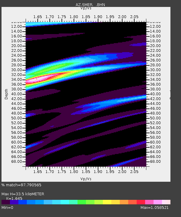
| Estimated Moho Depth: |
33.5 km |
| Estimated Crust Vp/Vs: |
1.64 |
| Assumed Crust Vp: |
6.264 km/s |
| Estimated Crust Vs: |
3.808 km/s |
| Estimated Crust Poisson's Ratio: |
0.21 |
|
| Radial Match: |
97.790565 % |
| Radial Bump: |
294 |
| Transverse Match: |
92.42884 % |
| Transverse Bump: |
400 |
| SOD ConfigId: |
2834 |
| Insert Time: |
2010-02-26 20:44:44.849 +0000 |
| GWidth: |
2.5 |
| Max Bumps: |
400 |
| Tol: |
0.001 |
|
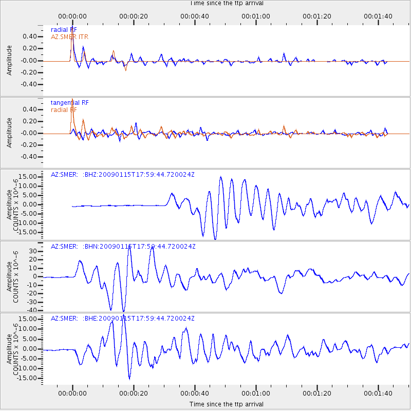
Signal To Noise
| Channel | StoN | STA | LTA |
| AZ:SMER: :BHN:20090115T17:59:44.720024Z | 68.51704 | 1.0014242E-5 | 1.4615696E-7 |
| AZ:SMER: :BHE:20090115T17:59:44.720024Z | 6.6881127 | 3.6629867E-6 | 5.4768617E-7 |
| AZ:SMER: :BHZ:20090115T17:59:44.720024Z | 16.415117 | 3.256793E-6 | 1.9840206E-7 |
| Arrivals |
| Ps | 3.6 SECOND |
| PpPs | 14 SECOND |
| PsPs/PpSs | 17 SECOND |


