You are here: Home > Network List > TA - USArray Transportable Network (new EarthScope stations) Stations List
> Station B34A Aery, Baudette, MN, USA > Earthquake Result Viewer
B34A Aery, Baudette, MN, USA - Earthquake Result Viewer
| Earthquake location: |
Eastern Honshu, Japan |
| Earthquake latitude/longitude: |
37.0/140.4 |
| Earthquake time(UTC): |
2011/04/11 (101) 08:16:12 GMT |
| Earthquake Depth: |
11 km |
| Earthquake Magnitude: |
6.4 MB, 6.5 MS, 6.6 MW, 6.6 MW |
| Earthquake Catalog/Contributor: |
WHDF/NEIC |
|
| Network: |
TA USArray Transportable Network (new EarthScope stations) |
| Station: |
B34A Aery, Baudette, MN, USA |
| Lat/Lon: |
48.49 N/94.65 W |
| Elevation: |
354 m |
|
| Distance: |
81.8 deg |
| Az: |
33.43 deg |
| Baz: |
318.476 deg |
| Ray Param: |
0.047316376 |
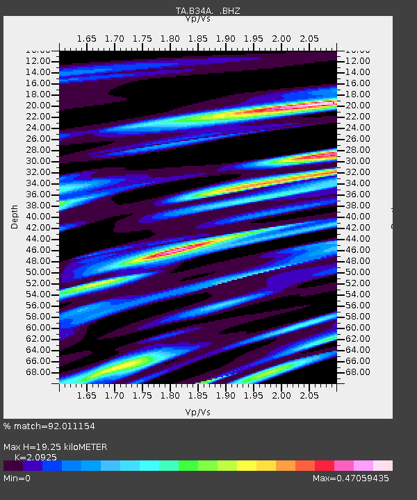
| Estimated Moho Depth: |
19.25 km |
| Estimated Crust Vp/Vs: |
2.09 |
| Assumed Crust Vp: |
6.419 km/s |
| Estimated Crust Vs: |
3.068 km/s |
| Estimated Crust Poisson's Ratio: |
0.35 |
|
| Radial Match: |
92.011154 % |
| Radial Bump: |
400 |
| Transverse Match: |
77.65544 % |
| Transverse Bump: |
400 |
| SOD ConfigId: |
356183 |
| Insert Time: |
2011-09-27 06:47:52.491 +0000 |
| GWidth: |
2.5 |
| Max Bumps: |
400 |
| Tol: |
0.001 |
|

Signal To Noise
| Channel | StoN | STA | LTA |
| TA:B34A: :BHZ:20110411T08:28:00.25002Z | 10.863246 | 2.6410587E-6 | 2.4311876E-7 |
| TA:B34A: :BHN:20110411T08:28:00.25002Z | 5.6977687 | 8.6842954E-7 | 1.5241574E-7 |
| TA:B34A: :BHE:20110411T08:28:00.25002Z | 4.336373 | 7.4123597E-7 | 1.7093456E-7 |
| Arrivals |
| Ps | 3.4 SECOND |
| PpPs | 9.1 SECOND |
| PsPs/PpSs | 12 SECOND |


