You are here: Home > Network List > TA - USArray Transportable Network (new EarthScope stations) Stations List
> Station N54A Moraine State Park, Portersville, PA, USA > Earthquake Result Viewer
N54A Moraine State Park, Portersville, PA, USA - Earthquake Result Viewer
| Earthquake location: |
Eastern Honshu, Japan |
| Earthquake latitude/longitude: |
37.0/140.4 |
| Earthquake time(UTC): |
2011/04/11 (101) 08:16:12 GMT |
| Earthquake Depth: |
11 km |
| Earthquake Magnitude: |
6.4 MB, 6.5 MS, 6.6 MW, 6.6 MW |
| Earthquake Catalog/Contributor: |
WHDF/NEIC |
|
| Network: |
TA USArray Transportable Network (new EarthScope stations) |
| Station: |
N54A Moraine State Park, Portersville, PA, USA |
| Lat/Lon: |
40.96 N/79.99 W |
| Elevation: |
408 m |
|
| Distance: |
94.0 deg |
| Az: |
29.469 deg |
| Baz: |
328.665 deg |
| Ray Param: |
0.04113598 |
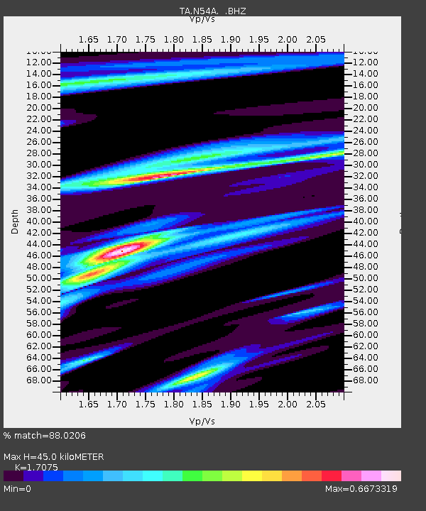
| Estimated Moho Depth: |
45.0 km |
| Estimated Crust Vp/Vs: |
1.71 |
| Assumed Crust Vp: |
6.121 km/s |
| Estimated Crust Vs: |
3.584 km/s |
| Estimated Crust Poisson's Ratio: |
0.24 |
|
| Radial Match: |
88.0206 % |
| Radial Bump: |
317 |
| Transverse Match: |
80.71464 % |
| Transverse Bump: |
400 |
| SOD ConfigId: |
356183 |
| Insert Time: |
2011-09-27 06:58:28.869 +0000 |
| GWidth: |
2.5 |
| Max Bumps: |
400 |
| Tol: |
0.001 |
|
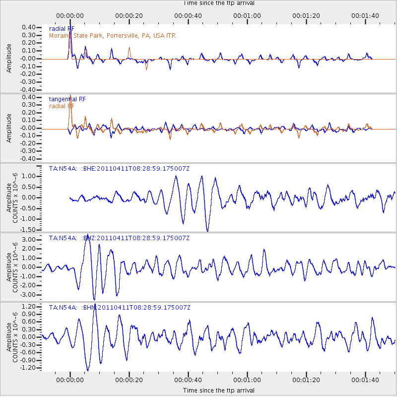
Signal To Noise
| Channel | StoN | STA | LTA |
| TA:N54A: :BHZ:20110411T08:28:59.175007Z | 5.205318 | 1.0544683E-6 | 2.025752E-7 |
| TA:N54A: :BHN:20110411T08:28:59.175007Z | 2.9521434 | 3.722879E-7 | 1.2610766E-7 |
| TA:N54A: :BHE:20110411T08:28:59.175007Z | 3.0187788 | 3.699536E-7 | 1.2255074E-7 |
| Arrivals |
| Ps | 5.3 SECOND |
| PpPs | 20 SECOND |
| PsPs/PpSs | 25 SECOND |


