You are here: Home > Network List > US - United States National Seismic Network Stations List
> Station LAO LASA Array, Montana, USA > Earthquake Result Viewer
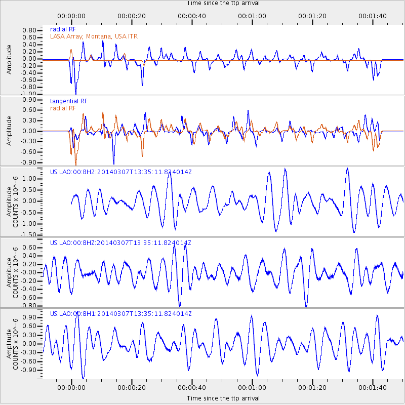
LAO LASA Array, Montana, USA - Earthquake Result Viewer
*The percent match for this event was below the threshold and hence no stack was calculated.
| Earthquake location: |
Kermadec Islands Region |
| Earthquake latitude/longitude: |
-28.4/-176.5 |
| Earthquake time(UTC): |
2014/03/07 (066) 13:22:09 GMT |
| Earthquake Depth: |
29 km |
| Earthquake Magnitude: |
5.0 MW |
| Earthquake Catalog/Contributor: |
ISC/ISC |
|
| Network: |
US United States National Seismic Network |
| Station: |
LAO LASA Array, Montana, USA |
| Lat/Lon: |
46.69 N/106.22 W |
| Elevation: |
902 m |
|
| Distance: |
98.0 deg |
| Az: |
40.89 deg |
| Baz: |
236.869 deg |
| Ray Param: |
$rayparam |
*The percent match for this event was below the threshold and hence was not used in the summary stack. |
|
| Radial Match: |
61.442192 % |
| Radial Bump: |
393 |
| Transverse Match: |
47.00626 % |
| Transverse Bump: |
275 |
| SOD ConfigId: |
3390531 |
| Insert Time: |
2019-04-10 13:23:49.039 +0000 |
| GWidth: |
2.5 |
| Max Bumps: |
400 |
| Tol: |
0.001 |
|
Signal To Noise
| Channel | StoN | STA | LTA |
| US:LAO:00:BHZ:20140307T13:35:11.824014Z | 1.1936448 | 2.5007876E-7 | 2.0950853E-7 |
| US:LAO:00:BH1:20140307T13:35:11.824014Z | 2.1364028 | 7.5367535E-7 | 3.5277773E-7 |
| US:LAO:00:BH2:20140307T13:35:11.824014Z | 2.7256389 | 8.8770406E-7 | 3.256866E-7 |
| Arrivals |
| Ps | |
| PpPs | |
| PsPs/PpSs | |


