You are here: Home > Network List > AZ - ANZA Regional Network Stations List
> Station SMER AZ.SMER > Earthquake Result Viewer
SMER AZ.SMER - Earthquake Result Viewer
| Earthquake location: |
Santa Cruz Islands |
| Earthquake latitude/longitude: |
-11.6/165.8 |
| Earthquake time(UTC): |
2007/09/02 (245) 01:05:18 GMT |
| Earthquake Depth: |
35 km |
| Earthquake Magnitude: |
5.9 MB, 7.3 MS, 7.2 MW, 6.9 ME |
| Earthquake Catalog/Contributor: |
WHDF/NEIC |
|
| Network: |
AZ ANZA Regional Network |
| Station: |
SMER AZ.SMER |
| Lat/Lon: |
33.46 N/117.17 W |
| Elevation: |
355 m |
|
| Distance: |
85.8 deg |
| Az: |
54.786 deg |
| Baz: |
253.245 deg |
| Ray Param: |
0.04447305 |
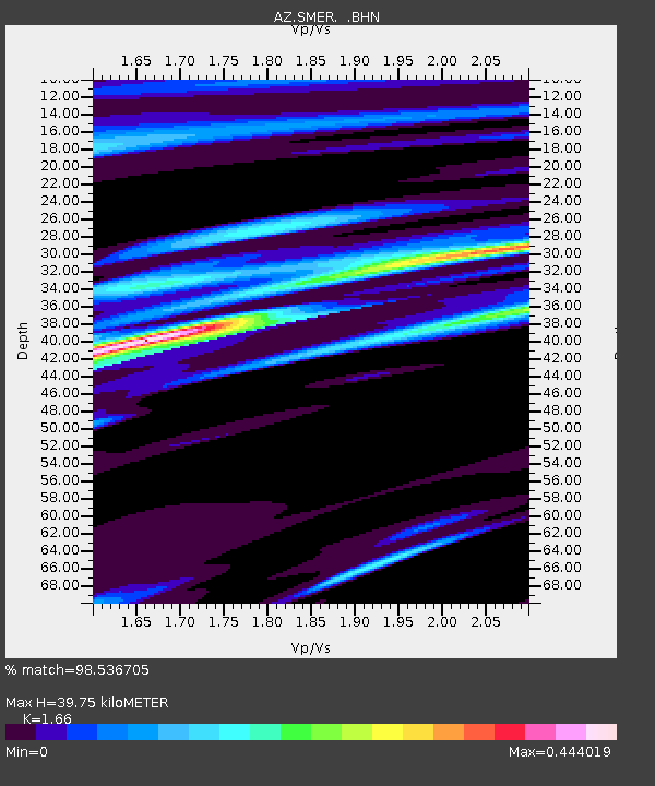
| Estimated Moho Depth: |
39.75 km |
| Estimated Crust Vp/Vs: |
1.66 |
| Assumed Crust Vp: |
6.264 km/s |
| Estimated Crust Vs: |
3.773 km/s |
| Estimated Crust Poisson's Ratio: |
0.22 |
|
| Radial Match: |
98.536705 % |
| Radial Bump: |
215 |
| Transverse Match: |
83.04952 % |
| Transverse Bump: |
400 |
| SOD ConfigId: |
2564 |
| Insert Time: |
2010-02-26 20:45:05.258 +0000 |
| GWidth: |
2.5 |
| Max Bumps: |
400 |
| Tol: |
0.001 |
|
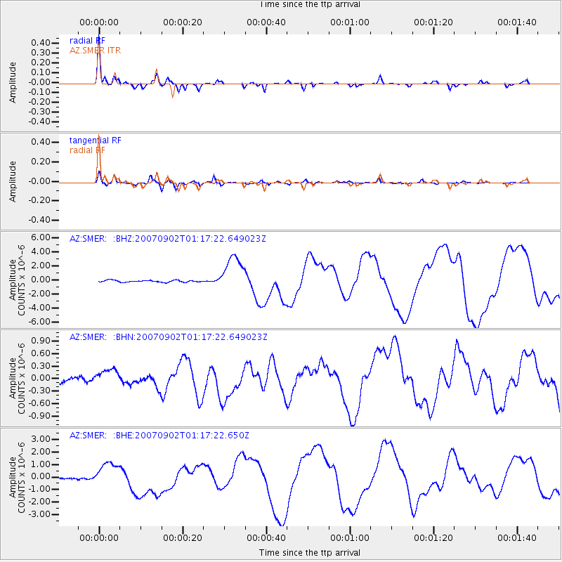
Signal To Noise
| Channel | StoN | STA | LTA |
| AZ:SMER: :BHN:20070902T01:17:22.649023Z | 2.4630113 | 1.8967036E-7 | 7.7007506E-8 |
| AZ:SMER: :BHE:20070902T01:17:22.650Z | 8.303931 | 9.3818704E-7 | 1.1298107E-7 |
| AZ:SMER: :BHZ:20070902T01:17:22.649023Z | 20.08511 | 2.6182975E-6 | 1.3036012E-7 |
| Arrivals |
| Ps | 4.3 SECOND |
| PpPs | 16 SECOND |
| PsPs/PpSs | 21 SECOND |


