You are here: Home > Network List > AZ - ANZA Regional Network Stations List
> Station SMER AZ.SMER > Earthquake Result Viewer
SMER AZ.SMER - Earthquake Result Viewer
| Earthquake location: |
Central Mid-Atlantic Ridge |
| Earthquake latitude/longitude: |
8.0/-39.2 |
| Earthquake time(UTC): |
2007/08/20 (232) 22:42:29 GMT |
| Earthquake Depth: |
10 km |
| Earthquake Magnitude: |
6.3 MB, 6.4 MS, 6.5 MW |
| Earthquake Catalog/Contributor: |
WHDF/NEIC |
|
| Network: |
AZ ANZA Regional Network |
| Station: |
SMER AZ.SMER |
| Lat/Lon: |
33.46 N/117.17 W |
| Elevation: |
355 m |
|
| Distance: |
75.6 deg |
| Az: |
302.417 deg |
| Baz: |
89.856 deg |
| Ray Param: |
0.05158986 |
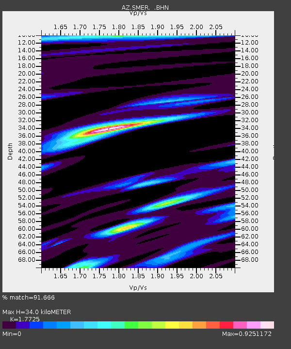
| Estimated Moho Depth: |
34.0 km |
| Estimated Crust Vp/Vs: |
1.77 |
| Assumed Crust Vp: |
6.264 km/s |
| Estimated Crust Vs: |
3.534 km/s |
| Estimated Crust Poisson's Ratio: |
0.27 |
|
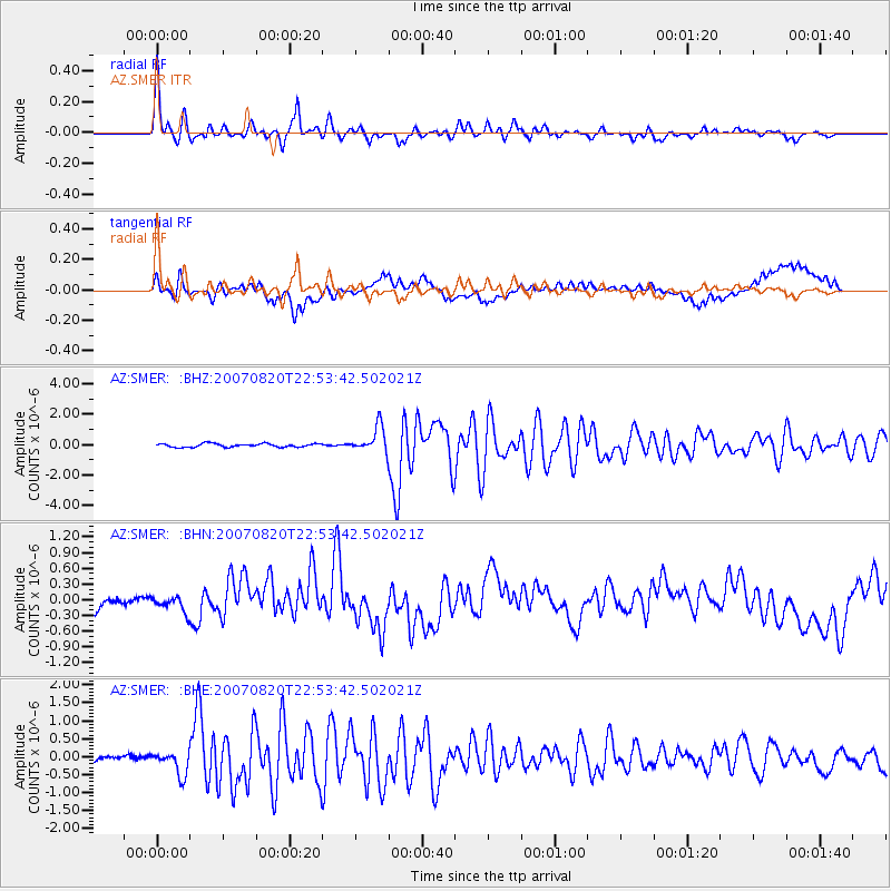
| Radial Match: |
91.666 % |
| Radial Bump: |
346 |
| Transverse Match: |
74.685684 % |
| Transverse Bump: |
400 |
| SOD ConfigId: |
2564 |
| Insert Time: |
2010-02-26 20:45:07.045 +0000 |
| GWidth: |
2.5 |
| Max Bumps: |
400 |
| Tol: |
0.001 |
|
Signal To Noise
| Channel | StoN | STA | LTA |
| AZ:SMER: :BHN:20070820T22:53:42.502021Z | 0.58045095 | 1.4142877E-7 | 2.4365326E-7 |
| AZ:SMER: :BHE:20070820T22:53:42.502021Z | 3.372 | 3.244055E-7 | 9.6205675E-8 |
| AZ:SMER: :BHZ:20070820T22:53:42.502021Z | 7.455474 | 8.5640994E-7 | 1.14869955E-7 |
| Arrivals |
| Ps | 4.3 SECOND |
| PpPs | 15 SECOND |
| PsPs/PpSs | 19 SECOND |


