You are here: Home > Network List > TA - USArray Transportable Network (new EarthScope stations) Stations List
> Station S40A Lebanon, MO, USA > Earthquake Result Viewer
S40A Lebanon, MO, USA - Earthquake Result Viewer
| Earthquake location: |
Eastern Honshu, Japan |
| Earthquake latitude/longitude: |
37.0/140.4 |
| Earthquake time(UTC): |
2011/04/11 (101) 08:16:12 GMT |
| Earthquake Depth: |
11 km |
| Earthquake Magnitude: |
6.4 MB, 6.5 MS, 6.6 MW, 6.6 MW |
| Earthquake Catalog/Contributor: |
WHDF/NEIC |
|
| Network: |
TA USArray Transportable Network (new EarthScope stations) |
| Station: |
S40A Lebanon, MO, USA |
| Lat/Lon: |
37.60 N/92.50 W |
| Elevation: |
336 m |
|
| Distance: |
91.1 deg |
| Az: |
39.319 deg |
| Baz: |
320.308 deg |
| Ray Param: |
0.041624915 |
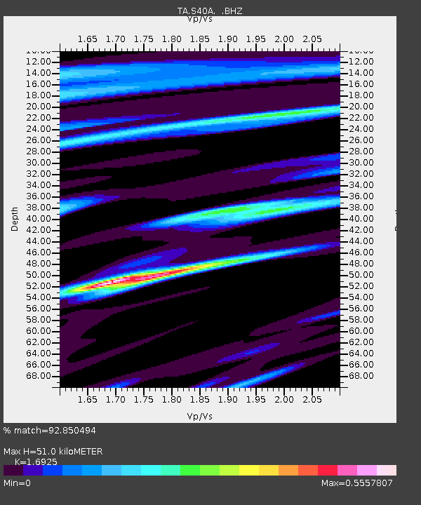
| Estimated Moho Depth: |
51.0 km |
| Estimated Crust Vp/Vs: |
1.69 |
| Assumed Crust Vp: |
6.53 km/s |
| Estimated Crust Vs: |
3.858 km/s |
| Estimated Crust Poisson's Ratio: |
0.23 |
|
| Radial Match: |
92.850494 % |
| Radial Bump: |
400 |
| Transverse Match: |
68.332375 % |
| Transverse Bump: |
400 |
| SOD ConfigId: |
356183 |
| Insert Time: |
2011-09-27 07:06:07.763 +0000 |
| GWidth: |
2.5 |
| Max Bumps: |
400 |
| Tol: |
0.001 |
|
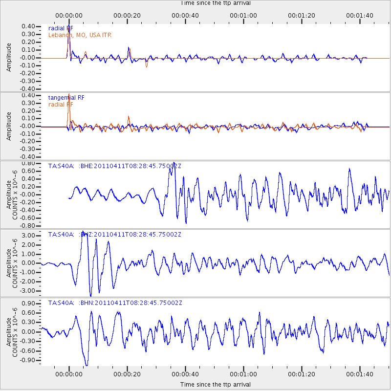
Signal To Noise
| Channel | StoN | STA | LTA |
| TA:S40A: :BHZ:20110411T08:28:45.75002Z | 13.073202 | 1.451935E-6 | 1.1106192E-7 |
| TA:S40A: :BHN:20110411T08:28:45.75002Z | 3.4960153 | 2.8093527E-7 | 8.035871E-8 |
| TA:S40A: :BHE:20110411T08:28:45.75002Z | 3.441987 | 3.2219558E-7 | 9.360743E-8 |
| Arrivals |
| Ps | 5.5 SECOND |
| PpPs | 21 SECOND |
| PsPs/PpSs | 26 SECOND |


