You are here: Home > Network List > TA - USArray Transportable Network (new EarthScope stations) Stations List
> Station S38A Stockton, MO, USA > Earthquake Result Viewer
S38A Stockton, MO, USA - Earthquake Result Viewer
| Earthquake location: |
Eastern Honshu, Japan |
| Earthquake latitude/longitude: |
37.0/140.4 |
| Earthquake time(UTC): |
2011/04/11 (101) 08:16:12 GMT |
| Earthquake Depth: |
11 km |
| Earthquake Magnitude: |
6.4 MB, 6.5 MS, 6.6 MW, 6.6 MW |
| Earthquake Catalog/Contributor: |
WHDF/NEIC |
|
| Network: |
TA USArray Transportable Network (new EarthScope stations) |
| Station: |
S38A Stockton, MO, USA |
| Lat/Lon: |
37.63 N/93.91 W |
| Elevation: |
294 m |
|
| Distance: |
90.4 deg |
| Az: |
40.153 deg |
| Baz: |
319.443 deg |
| Ray Param: |
0.04167797 |
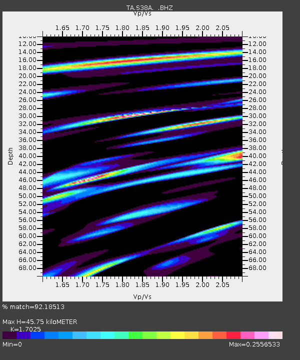
| Estimated Moho Depth: |
45.75 km |
| Estimated Crust Vp/Vs: |
1.70 |
| Assumed Crust Vp: |
6.53 km/s |
| Estimated Crust Vs: |
3.836 km/s |
| Estimated Crust Poisson's Ratio: |
0.24 |
|
| Radial Match: |
92.18513 % |
| Radial Bump: |
396 |
| Transverse Match: |
73.49855 % |
| Transverse Bump: |
400 |
| SOD ConfigId: |
356183 |
| Insert Time: |
2011-09-27 07:06:12.210 +0000 |
| GWidth: |
2.5 |
| Max Bumps: |
400 |
| Tol: |
0.001 |
|

Signal To Noise
| Channel | StoN | STA | LTA |
| TA:S38A: :BHZ:20110411T08:28:42.300007Z | 10.409331 | 1.7026056E-6 | 1.6356532E-7 |
| TA:S38A: :BHN:20110411T08:28:42.300007Z | 4.341836 | 3.317101E-7 | 7.6398585E-8 |
| TA:S38A: :BHE:20110411T08:28:42.300007Z | 2.973823 | 3.0681994E-7 | 1.0317357E-7 |
| Arrivals |
| Ps | 5.0 SECOND |
| PpPs | 19 SECOND |
| PsPs/PpSs | 24 SECOND |


