You are here: Home > Network List > TA - USArray Transportable Network (new EarthScope stations) Stations List
> Station X39A Fountain Ranch, Mena, AR, USA > Earthquake Result Viewer
X39A Fountain Ranch, Mena, AR, USA - Earthquake Result Viewer
| Earthquake location: |
Eastern Honshu, Japan |
| Earthquake latitude/longitude: |
37.0/140.4 |
| Earthquake time(UTC): |
2011/04/11 (101) 08:16:12 GMT |
| Earthquake Depth: |
11 km |
| Earthquake Magnitude: |
6.4 MB, 6.5 MS, 6.6 MW, 6.6 MW |
| Earthquake Catalog/Contributor: |
WHDF/NEIC |
|
| Network: |
TA USArray Transportable Network (new EarthScope stations) |
| Station: |
X39A Fountain Ranch, Mena, AR, USA |
| Lat/Lon: |
34.51 N/94.11 W |
| Elevation: |
326 m |
|
| Distance: |
92.6 deg |
| Az: |
42.308 deg |
| Baz: |
319.265 deg |
| Ray Param: |
0.041421026 |
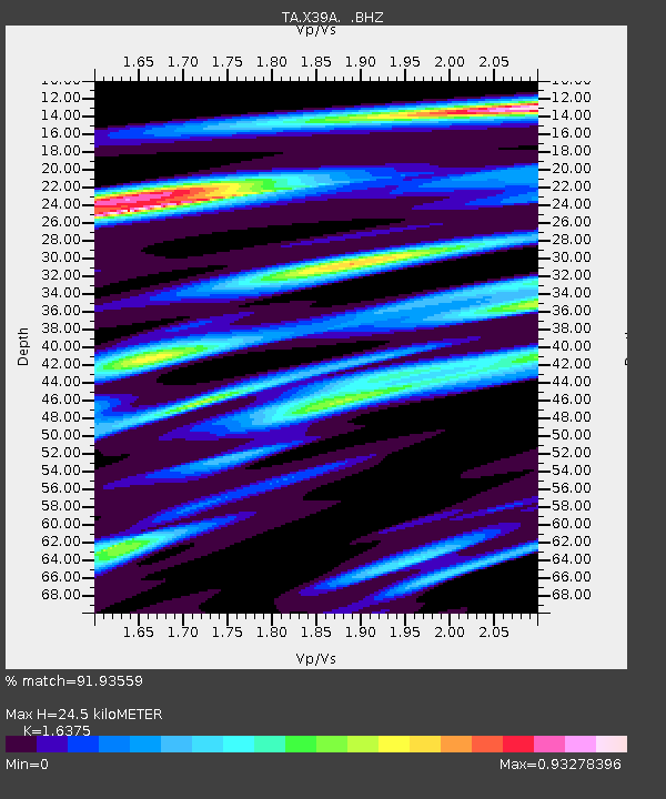
| Estimated Moho Depth: |
24.5 km |
| Estimated Crust Vp/Vs: |
1.64 |
| Assumed Crust Vp: |
6.498 km/s |
| Estimated Crust Vs: |
3.968 km/s |
| Estimated Crust Poisson's Ratio: |
0.20 |
|
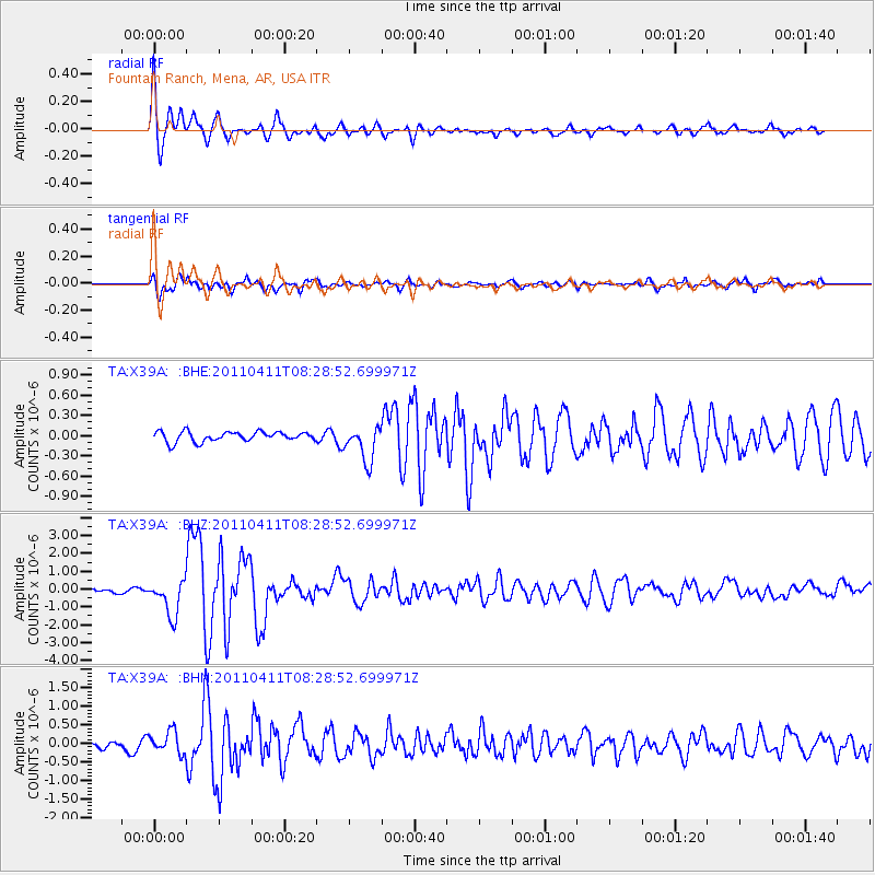
| Radial Match: |
91.93559 % |
| Radial Bump: |
400 |
| Transverse Match: |
85.93876 % |
| Transverse Bump: |
400 |
| SOD ConfigId: |
356183 |
| Insert Time: |
2011-09-27 07:07:48.309 +0000 |
| GWidth: |
2.5 |
| Max Bumps: |
400 |
| Tol: |
0.001 |
|
Signal To Noise
| Channel | StoN | STA | LTA |
| TA:X39A: :BHZ:20110411T08:28:52.699971Z | 7.574449 | 9.922903E-7 | 1.3100495E-7 |
| TA:X39A: :BHN:20110411T08:28:52.699971Z | 2.3047392 | 2.9602143E-7 | 1.2844032E-7 |
| TA:X39A: :BHE:20110411T08:28:52.699971Z | 3.5825298 | 2.6131292E-7 | 7.2940885E-8 |
| Arrivals |
| Ps | 2.5 SECOND |
| PpPs | 9.7 SECOND |
| PsPs/PpSs | 12 SECOND |


