You are here: Home > Network List > TA - USArray Transportable Network (new EarthScope stations) Stations List
> Station 242A Grayson, LA, USA > Earthquake Result Viewer
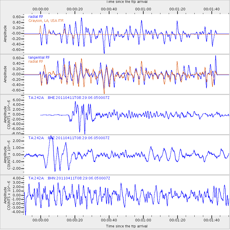
242A Grayson, LA, USA - Earthquake Result Viewer
*The percent match for this event was below the threshold and hence no stack was calculated.
| Earthquake location: |
Eastern Honshu, Japan |
| Earthquake latitude/longitude: |
37.0/140.4 |
| Earthquake time(UTC): |
2011/04/11 (101) 08:16:12 GMT |
| Earthquake Depth: |
11 km |
| Earthquake Magnitude: |
6.4 MB, 6.5 MS, 6.6 MW, 6.6 MW |
| Earthquake Catalog/Contributor: |
WHDF/NEIC |
|
| Network: |
TA USArray Transportable Network (new EarthScope stations) |
| Station: |
242A Grayson, LA, USA |
| Lat/Lon: |
32.06 N/92.15 W |
| Elevation: |
57 m |
|
| Distance: |
95.6 deg |
| Az: |
42.631 deg |
| Baz: |
320.314 deg |
| Ray Param: |
$rayparam |
*The percent match for this event was below the threshold and hence was not used in the summary stack. |
|
| Radial Match: |
42.21046 % |
| Radial Bump: |
400 |
| Transverse Match: |
38.821243 % |
| Transverse Bump: |
400 |
| SOD ConfigId: |
356183 |
| Insert Time: |
2011-09-27 07:12:23.533 +0000 |
| GWidth: |
2.5 |
| Max Bumps: |
400 |
| Tol: |
0.001 |
|
Signal To Noise
| Channel | StoN | STA | LTA |
| TA:242A: :BHZ:20110411T08:29:06.050007Z | 5.24472 | 8.219884E-7 | 1.5672684E-7 |
| TA:242A: :BHN:20110411T08:29:06.050007Z | 0.8969667 | 1.5914864E-6 | 1.7742981E-6 |
| TA:242A: :BHE:20110411T08:29:06.050007Z | 1.042289 | 1.7709813E-6 | 1.6991268E-6 |
| Arrivals |
| Ps | |
| PpPs | |
| PsPs/PpSs | |


