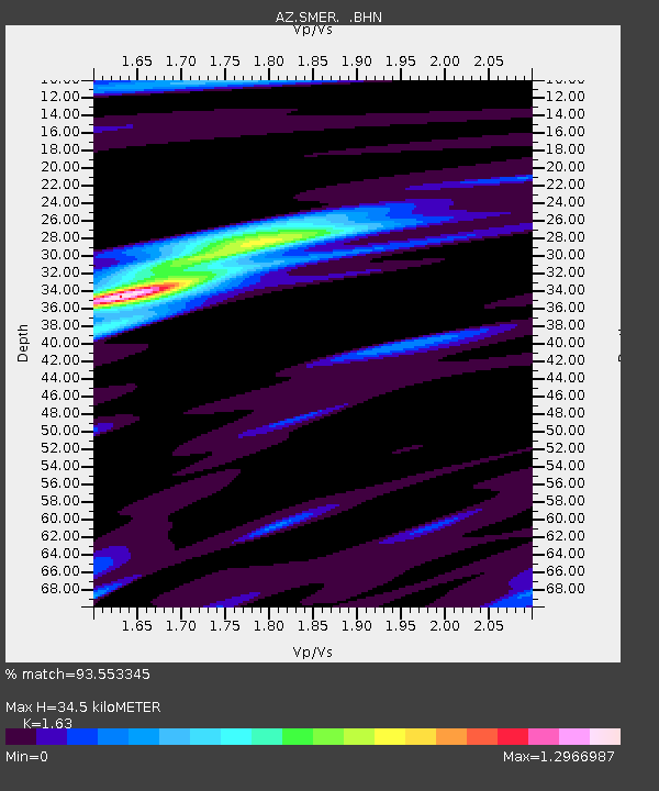
SMER AZ.SMER - Earthquake Result Viewer
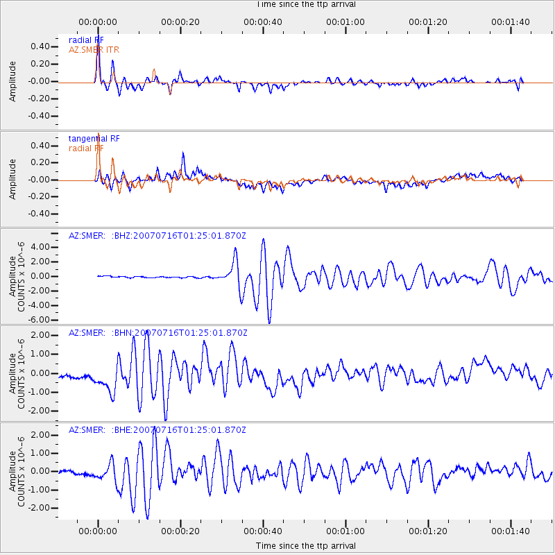
Earthquake location: Near West Coast Of Honshu, Japan
Earthquake latitude/longitude: 37.5/138.4
Earthquake time(UTC): 2007/07/16 (197) 01:13:22 GMT
Earthquake Depth: 12 km
Earthquake Magnitude: 6.5 MB, 6.4 MS, 6.6 MW, 6.5 MW
Earthquake Catalog/Contributor: WHDF/NEIC
Network: AZ ANZA Regional Network
Station: SMER AZ.SMER
Lat/Lon: 33.46 N/117.17 W
Elevation: 355 m
Distance: 80.3 deg
Az: 55.229 deg
Baz: 308.637 deg
Ray Param: 0.0483407
Estimated Moho Depth: 34.5 km
Estimated Crust Vp/Vs: 1.63
Assumed Crust Vp: 6.264 km/s
Estimated Crust Vs: 3.843 km/s
Estimated Crust Poisson's Ratio: 0.20
Radial Match: 93.553345 %
Radial Bump: 400
Transverse Match: 73.30374 %
Transverse Bump: 400
SOD ConfigId: 2564
Insert Time: 2010-02-26 20:45:22.531 +0000
GWidth: 2.5
Max Bumps: 400
Tol: 0.001

Signal To Noise

ChannelStoNSTALTA
AZ:SMER: :BHN:20070716T01:25:01.870Z3.29834158.6819387E-72.6322132E-7
AZ:SMER: :BHE:20070716T01:25:01.870Z4.84602985.082585E-71.0488142E-7
AZ:SMER: :BHZ:20070716T01:25:01.870Z19.4047161.8555739E-69.562489E-8
Arrivals
Ps3.6 SECOND
PpPs14 SECOND
PsPs/PpSs18 SECOND