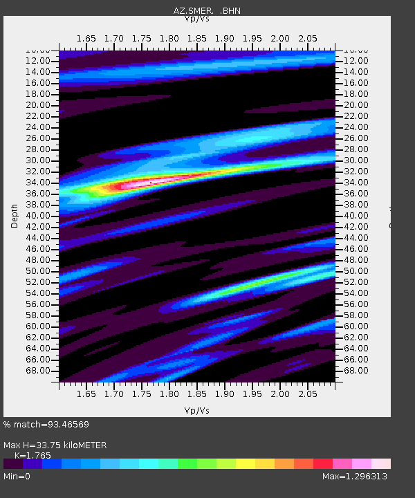
SMER AZ.SMER - Earthquake Result Viewer
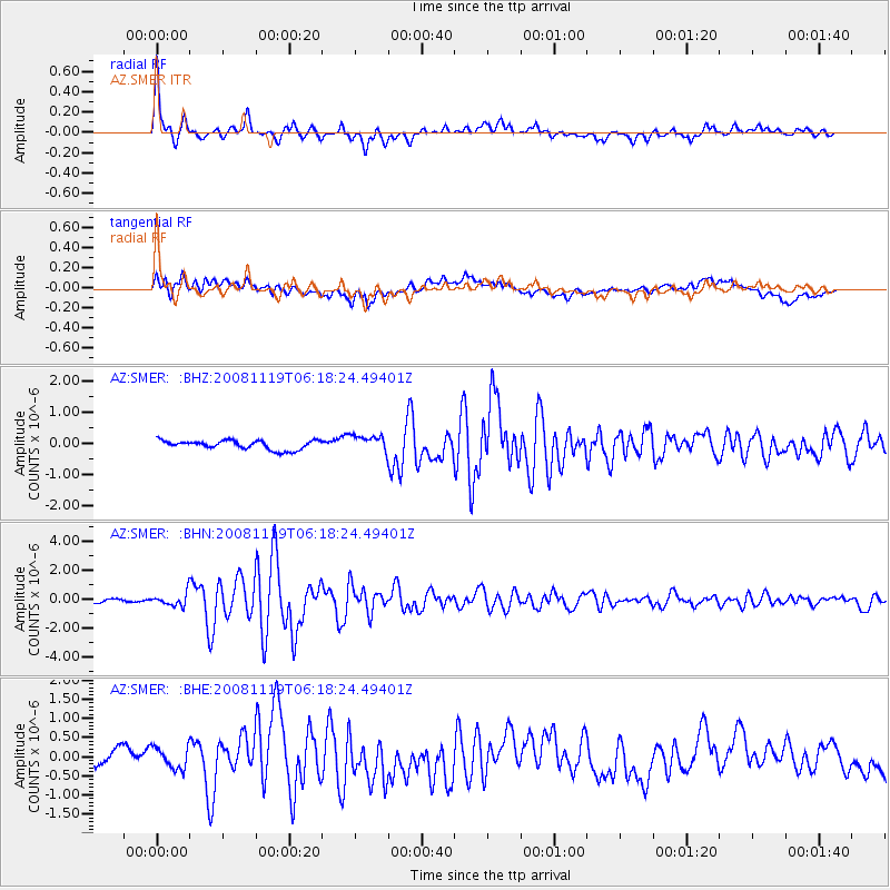
Earthquake location: Panama-Costa Rica Border Region
Earthquake latitude/longitude: 8.3/-83.0
Earthquake time(UTC): 2008/11/19 (324) 06:11:20 GMT
Earthquake Depth: 32 km
Earthquake Magnitude: 5.9 MB, 5.9 MS, 6.2 MW, 6.1 MW
Earthquake Catalog/Contributor: WHDF/NEIC
Network: AZ ANZA Regional Network
Station: SMER AZ.SMER
Lat/Lon: 33.46 N/117.17 W
Elevation: 355 m
Distance: 40.3 deg
Az: 313.397 deg
Baz: 120.655 deg
Ray Param: 0.07442257
Estimated Moho Depth: 33.75 km
Estimated Crust Vp/Vs: 1.76
Assumed Crust Vp: 6.264 km/s
Estimated Crust Vs: 3.549 km/s
Estimated Crust Poisson's Ratio: 0.26
Radial Match: 93.46569 %
Radial Bump: 400
Transverse Match: 70.48383 %
Transverse Bump: 400
SOD ConfigId: 2658
Insert Time: 2010-02-26 20:45:32.457 +0000
GWidth: 2.5
Max Bumps: 400
Tol: 0.001

Signal To Noise

ChannelStoNSTALTA
AZ:SMER: :BHN:20081119T06:18:24.49401Z2.48293764.41127E-71.7766335E-7
AZ:SMER: :BHE:20081119T06:18:24.49401Z1.00131122.8330862E-72.8293766E-7
AZ:SMER: :BHZ:20081119T06:18:24.49401Z1.81771762.655498E-71.460897E-7
Arrivals
Ps4.4 SECOND
PpPs14 SECOND
PsPs/PpSs18 SECOND