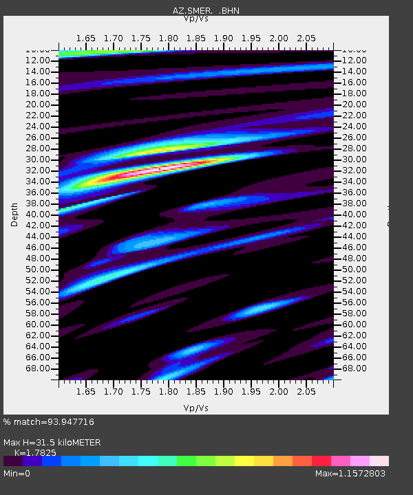
SMER AZ.SMER - Earthquake Result Viewer
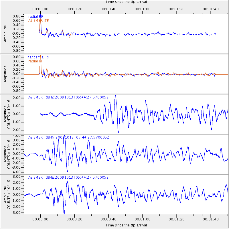
Earthquake location: Fox Islands, Aleutian Islands
Earthquake latitude/longitude: 52.8/-167.0
Earthquake time(UTC): 2009/10/13 (286) 05:37:23 GMT
Earthquake Depth: 24 km
Earthquake Magnitude: 6.0 MB, 6.1 MS, 6.5 MW, 6.5 MW
Earthquake Catalog/Contributor: WHDF/NEIC
Network: AZ ANZA Regional Network
Station: SMER AZ.SMER
Lat/Lon: 33.46 N/117.17 W
Elevation: 355 m
Distance: 40.2 deg
Az: 98.434 deg
Baz: 314.012 deg
Ray Param: 0.074484244
Estimated Moho Depth: 31.5 km
Estimated Crust Vp/Vs: 1.78
Assumed Crust Vp: 6.264 km/s
Estimated Crust Vs: 3.514 km/s
Estimated Crust Poisson's Ratio: 0.27
Radial Match: 93.947716 %
Radial Bump: 374
Transverse Match: 88.26925 %
Transverse Bump: 400
SOD ConfigId: 2622
Insert Time: 2010-02-26 20:45:43.971 +0000
GWidth: 2.5
Max Bumps: 400
Tol: 0.001

Signal To Noise

ChannelStoNSTALTA
AZ:SMER: :BHN:20091013T05:44:27.570005Z3.63471636.897907E-71.8977842E-7
AZ:SMER: :BHE:20091013T05:44:27.570005Z2.42372474.4086704E-71.8189651E-7
AZ:SMER: :BHZ:20091013T05:44:27.570005Z3.3289343.812557E-71.1452786E-7
Arrivals
Ps4.2 SECOND
PpPs13 SECOND
PsPs/PpSs17 SECOND