You are here: Home > Network List > TA - USArray Transportable Network (new EarthScope stations) Stations List
> Station K04D Chiloquin, OR, USA > Earthquake Result Viewer
K04D Chiloquin, OR, USA - Earthquake Result Viewer

| Earthquake location: |
Eastern Honshu, Japan |
| Earthquake latitude/longitude: |
37.8/140.8 |
| Earthquake time(UTC): |
2011/04/11 (101) 08:16:50 GMT |
| Earthquake Depth: |
10 km |
| Earthquake Magnitude: |
5.8 MB |
| Earthquake Catalog/Contributor: |
WHDF/NEIC |
|
| Network: |
TA USArray Transportable Network (new EarthScope stations) |
| Station: |
K04D Chiloquin, OR, USA |
| Lat/Lon: |
42.62 N/121.75 W |
| Elevation: |
1315 m |
|
| Distance: |
70.4 deg |
| Az: |
50.992 deg |
| Baz: |
303.479 deg |
| Ray Param: |
0.055032995 |
| Estimated Moho Depth: |
40.25 km |
| Estimated Crust Vp/Vs: |
1.61 |
| Assumed Crust Vp: |
6.597 km/s |
| Estimated Crust Vs: |
4.111 km/s |
| Estimated Crust Poisson's Ratio: |
0.18 |
|
| Radial Match: |
80.7193 % |
| Radial Bump: |
400 |
| Transverse Match: |
80.67472 % |
| Transverse Bump: |
400 |
| SOD ConfigId: |
356183 |
| Insert Time: |
2011-09-27 08:05:02.220 +0000 |
| GWidth: |
2.5 |
| Max Bumps: |
400 |
| Tol: |
0.001 |
|
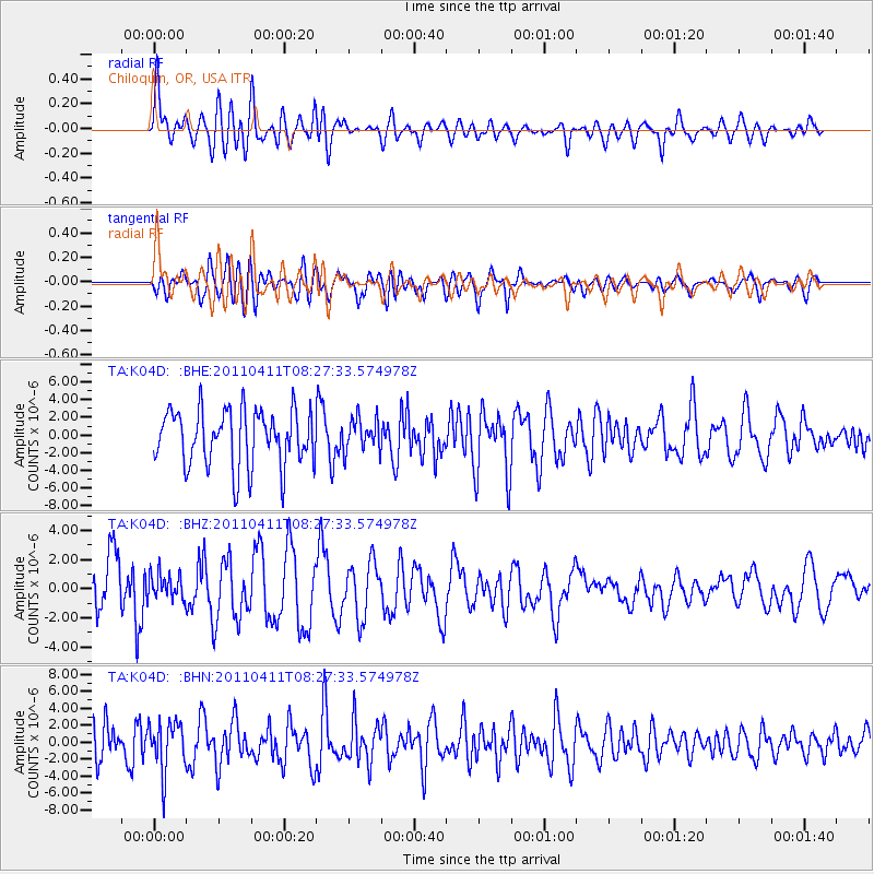
Signal To Noise
| Channel | StoN | STA | LTA |
| TA:K04D: :BHZ:20110411T08:27:33.574978Z | 0.18707801 | 8.547569E-7 | 4.5689862E-6 |
| TA:K04D: :BHN:20110411T08:27:33.574978Z | 1.2108324 | 2.9455184E-6 | 2.4326391E-6 |
| TA:K04D: :BHE:20110411T08:27:33.574978Z | 0.5946018 | 1.8857455E-6 | 3.1714426E-6 |
| Arrivals |
| Ps | 3.9 SECOND |
| PpPs | 15 SECOND |
| PsPs/PpSs | 19 SECOND |


