You are here: Home > Network List > TA - USArray Transportable Network (new EarthScope stations) Stations List
> Station 138A Matatall Enterprise, Big Sandy, TX, USA > Earthquake Result Viewer
138A Matatall Enterprise, Big Sandy, TX, USA - Earthquake Result Viewer
| Earthquake location: |
Eastern Honshu, Japan |
| Earthquake latitude/longitude: |
37.8/140.8 |
| Earthquake time(UTC): |
2011/04/11 (101) 08:16:50 GMT |
| Earthquake Depth: |
10 km |
| Earthquake Magnitude: |
5.8 MB |
| Earthquake Catalog/Contributor: |
WHDF/NEIC |
|
| Network: |
TA USArray Transportable Network (new EarthScope stations) |
| Station: |
138A Matatall Enterprise, Big Sandy, TX, USA |
| Lat/Lon: |
32.66 N/95.09 W |
| Elevation: |
143 m |
|
| Distance: |
92.7 deg |
| Az: |
44.368 deg |
| Baz: |
318.948 deg |
| Ray Param: |
0.041408844 |
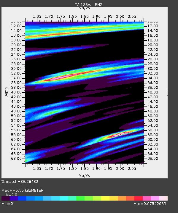
| Estimated Moho Depth: |
57.5 km |
| Estimated Crust Vp/Vs: |
2.00 |
| Assumed Crust Vp: |
6.245 km/s |
| Estimated Crust Vs: |
3.123 km/s |
| Estimated Crust Poisson's Ratio: |
0.33 |
|
| Radial Match: |
88.26482 % |
| Radial Bump: |
353 |
| Transverse Match: |
67.10607 % |
| Transverse Bump: |
400 |
| SOD ConfigId: |
356183 |
| Insert Time: |
2011-09-27 08:08:53.303 +0000 |
| GWidth: |
2.5 |
| Max Bumps: |
400 |
| Tol: |
0.001 |
|
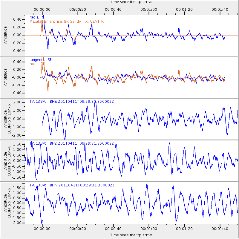
Signal To Noise
| Channel | StoN | STA | LTA |
| TA:138A: :BHZ:20110411T08:29:31.350002Z | 0.38793635 | 6.2575197E-7 | 1.6130274E-6 |
| TA:138A: :BHN:20110411T08:29:31.350002Z | 1.4806235 | 1.0690245E-6 | 7.220097E-7 |
| TA:138A: :BHE:20110411T08:29:31.350002Z | 1.313847 | 1.1164861E-6 | 8.49784E-7 |
| Arrivals |
| Ps | 9.4 SECOND |
| PpPs | 27 SECOND |
| PsPs/PpSs | 37 SECOND |


