You are here: Home > Network List > TA - USArray Transportable Network (new EarthScope stations) Stations List
> Station L33A Hoskins, NE, USA > Earthquake Result Viewer
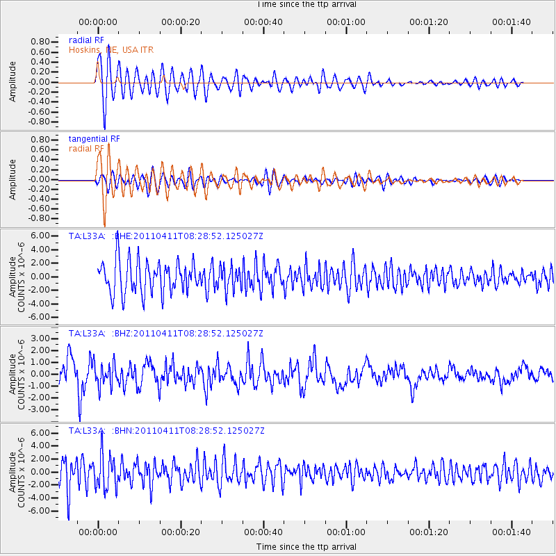
L33A Hoskins, NE, USA - Earthquake Result Viewer
*The percent match for this event was below the threshold and hence no stack was calculated.
| Earthquake location: |
Eastern Honshu, Japan |
| Earthquake latitude/longitude: |
37.8/140.8 |
| Earthquake time(UTC): |
2011/04/11 (101) 08:16:50 GMT |
| Earthquake Depth: |
10 km |
| Earthquake Magnitude: |
5.8 MB |
| Earthquake Catalog/Contributor: |
WHDF/NEIC |
|
| Network: |
TA USArray Transportable Network (new EarthScope stations) |
| Station: |
L33A Hoskins, NE, USA |
| Lat/Lon: |
42.17 N/97.27 W |
| Elevation: |
556 m |
|
| Distance: |
84.4 deg |
| Az: |
39.348 deg |
| Baz: |
317.496 deg |
| Ray Param: |
$rayparam |
*The percent match for this event was below the threshold and hence was not used in the summary stack. |
|
| Radial Match: |
89.65441 % |
| Radial Bump: |
400 |
| Transverse Match: |
77.32442 % |
| Transverse Bump: |
400 |
| SOD ConfigId: |
356183 |
| Insert Time: |
2011-09-27 08:11:03.014 +0000 |
| GWidth: |
2.5 |
| Max Bumps: |
400 |
| Tol: |
0.001 |
|
Signal To Noise
| Channel | StoN | STA | LTA |
| TA:L33A: :BHZ:20110411T08:28:52.125027Z | 0.30015844 | 9.530562E-7 | 3.175177E-6 |
| TA:L33A: :BHN:20110411T08:28:52.125027Z | 1.0862788 | 2.6432256E-6 | 2.4332849E-6 |
| TA:L33A: :BHE:20110411T08:28:52.125027Z | 0.7273025 | 1.700828E-6 | 2.3385428E-6 |
| Arrivals |
| Ps | |
| PpPs | |
| PsPs/PpSs | |


