You are here: Home > Network List > UW - Pacific Northwest Regional Seismic Network Stations List
> Station UMAT Pilot Rock, OR, USA > Earthquake Result Viewer
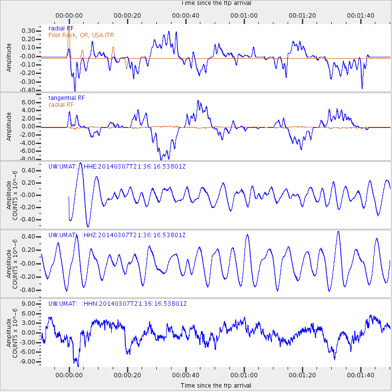
UMAT Pilot Rock, OR, USA - Earthquake Result Viewer
*The percent match for this event was below the threshold and hence no stack was calculated.
| Earthquake location: |
Eastern New Guinea Reg., P.N.G. |
| Earthquake latitude/longitude: |
-6.3/147.9 |
| Earthquake time(UTC): |
2014/03/07 (066) 21:23:22 GMT |
| Earthquake Depth: |
42 km |
| Earthquake Magnitude: |
5.1 MW |
| Earthquake Catalog/Contributor: |
ISC/ISC |
|
| Network: |
UW Pacific Northwest Regional Seismic Network |
| Station: |
UMAT Pilot Rock, OR, USA |
| Lat/Lon: |
45.29 N/118.96 W |
| Elevation: |
1318 m |
|
| Distance: |
96.6 deg |
| Az: |
45.203 deg |
| Baz: |
267.77 deg |
| Ray Param: |
$rayparam |
*The percent match for this event was below the threshold and hence was not used in the summary stack. |
|
| Radial Match: |
55.14724 % |
| Radial Bump: |
400 |
| Transverse Match: |
50.020905 % |
| Transverse Bump: |
400 |
| SOD ConfigId: |
3390531 |
| Insert Time: |
2019-04-10 13:30:49.961 +0000 |
| GWidth: |
2.5 |
| Max Bumps: |
400 |
| Tol: |
0.001 |
|
Signal To Noise
| Channel | StoN | STA | LTA |
| UW:UMAT: :HHZ:20140307T21:36:16.53801Z | 1.4259036 | 2.677549E-7 | 1.8777912E-7 |
| UW:UMAT: :HHN:20140307T21:36:16.53801Z | 3.0312345 | 6.187103E-6 | 2.0411164E-6 |
| UW:UMAT: :HHE:20140307T21:36:16.53801Z | 0.41608995 | 9.2376844E-8 | 2.2201172E-7 |
| Arrivals |
| Ps | |
| PpPs | |
| PsPs/PpSs | |


