You are here: Home > Network List > TA - USArray Transportable Network (new EarthScope stations) Stations List
> Station U39A Green Forest, AR, USA > Earthquake Result Viewer
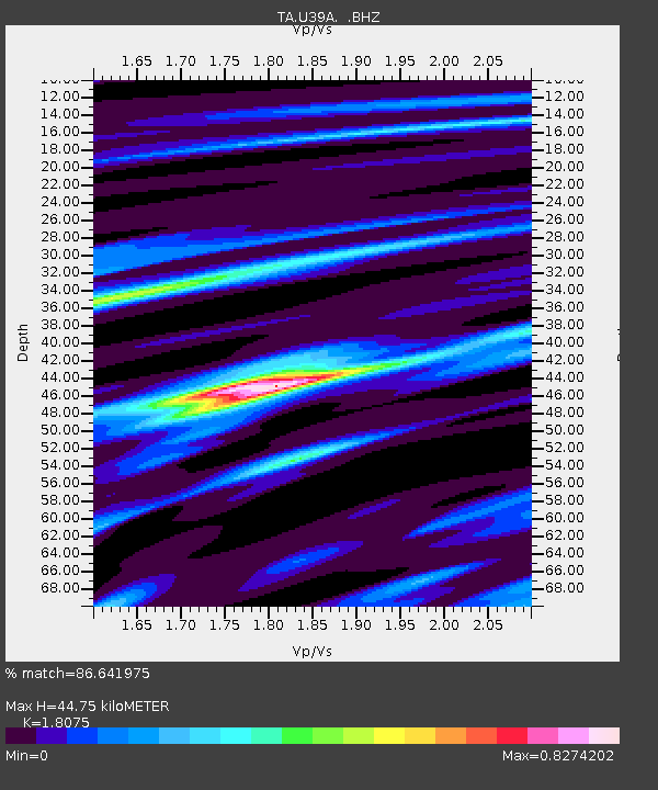
U39A Green Forest, AR, USA - Earthquake Result Viewer
| Earthquake location: |
Eastern Honshu, Japan |
| Earthquake latitude/longitude: |
37.8/140.8 |
| Earthquake time(UTC): |
2011/04/11 (101) 08:16:50 GMT |
| Earthquake Depth: |
10 km |
| Earthquake Magnitude: |
5.8 MB |
| Earthquake Catalog/Contributor: |
WHDF/NEIC |
|
| Network: |
TA USArray Transportable Network (new EarthScope stations) |
| Station: |
U39A Green Forest, AR, USA |
| Lat/Lon: |
36.38 N/93.48 W |
| Elevation: |
433 m |
|
| Distance: |
90.7 deg |
| Az: |
40.944 deg |
| Baz: |
319.957 deg |
| Ray Param: |
0.0416525 |
| Estimated Moho Depth: |
44.75 km |
| Estimated Crust Vp/Vs: |
1.81 |
| Assumed Crust Vp: |
6.53 km/s |
| Estimated Crust Vs: |
3.613 km/s |
| Estimated Crust Poisson's Ratio: |
0.28 |
|
| Radial Match: |
86.641975 % |
| Radial Bump: |
400 |
| Transverse Match: |
75.36734 % |
| Transverse Bump: |
400 |
| SOD ConfigId: |
356183 |
| Insert Time: |
2011-09-27 08:17:59.342 +0000 |
| GWidth: |
2.5 |
| Max Bumps: |
400 |
| Tol: |
0.001 |
|

Signal To Noise
| Channel | StoN | STA | LTA |
| TA:U39A: :BHZ:20110411T08:29:22.324978Z | 0.28149146 | 4.968521E-7 | 1.7650699E-6 |
| TA:U39A: :BHN:20110411T08:29:22.324978Z | 0.5477657 | 2.931468E-7 | 5.351682E-7 |
| TA:U39A: :BHE:20110411T08:29:22.324978Z | 0.55008364 | 2.560952E-7 | 4.6555684E-7 |
| Arrivals |
| Ps | 5.7 SECOND |
| PpPs | 19 SECOND |
| PsPs/PpSs | 24 SECOND |


