You are here: Home > Network List > TA - USArray Transportable Network (new EarthScope stations) Stations List
> Station W39A Magazine, AR, USA > Earthquake Result Viewer
W39A Magazine, AR, USA - Earthquake Result Viewer
| Earthquake location: |
Eastern Honshu, Japan |
| Earthquake latitude/longitude: |
37.8/140.8 |
| Earthquake time(UTC): |
2011/04/11 (101) 08:16:50 GMT |
| Earthquake Depth: |
10 km |
| Earthquake Magnitude: |
5.8 MB |
| Earthquake Catalog/Contributor: |
WHDF/NEIC |
|
| Network: |
TA USArray Transportable Network (new EarthScope stations) |
| Station: |
W39A Magazine, AR, USA |
| Lat/Lon: |
35.20 N/93.78 W |
| Elevation: |
162 m |
|
| Distance: |
91.5 deg |
| Az: |
41.896 deg |
| Baz: |
319.762 deg |
| Ray Param: |
0.0415993 |
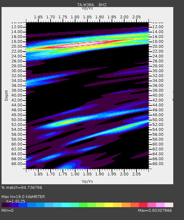
| Estimated Moho Depth: |
19.0 km |
| Estimated Crust Vp/Vs: |
1.81 |
| Assumed Crust Vp: |
6.498 km/s |
| Estimated Crust Vs: |
3.585 km/s |
| Estimated Crust Poisson's Ratio: |
0.28 |
|
| Radial Match: |
84.736786 % |
| Radial Bump: |
400 |
| Transverse Match: |
67.18634 % |
| Transverse Bump: |
400 |
| SOD ConfigId: |
356183 |
| Insert Time: |
2011-09-27 08:18:01.606 +0000 |
| GWidth: |
2.5 |
| Max Bumps: |
400 |
| Tol: |
0.001 |
|
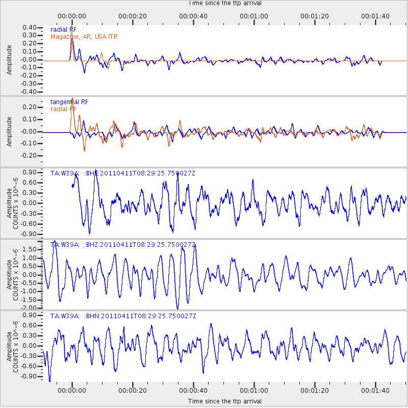
Signal To Noise
| Channel | StoN | STA | LTA |
| TA:W39A: :BHZ:20110411T08:29:25.750027Z | 0.22407699 | 4.1252497E-7 | 1.8409966E-6 |
| TA:W39A: :BHN:20110411T08:29:25.750027Z | 0.54867613 | 2.754409E-7 | 5.0201E-7 |
| TA:W39A: :BHE:20110411T08:29:25.750027Z | 1.2585735 | 4.9371937E-7 | 3.922849E-7 |
| Arrivals |
| Ps | 2.4 SECOND |
| PpPs | 8.1 SECOND |
| PsPs/PpSs | 10 SECOND |


