You are here: Home > Network List > CI - Caltech Regional Seismic Network Stations List
> Station MPM Manuel Prospect Mine, California, USA > Earthquake Result Viewer
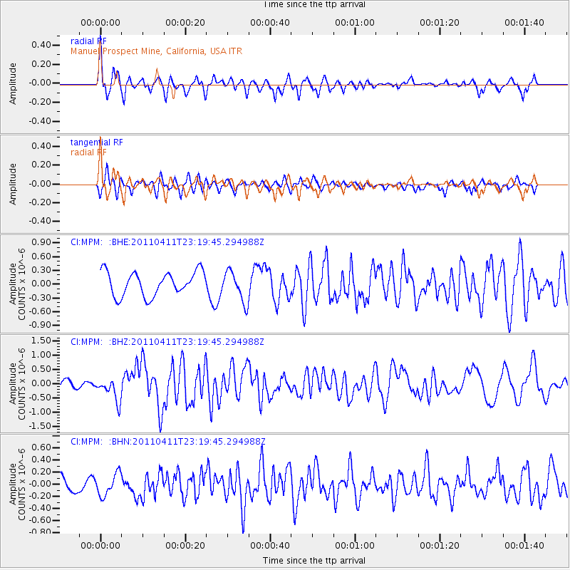
MPM Manuel Prospect Mine, California, USA - Earthquake Result Viewer
*The percent match for this event was below the threshold and hence no stack was calculated.
| Earthquake location: |
Near East Coast Of Honshu, Japan |
| Earthquake latitude/longitude: |
35.4/140.6 |
| Earthquake time(UTC): |
2011/04/11 (101) 23:08:16 GMT |
| Earthquake Depth: |
15 km |
| Earthquake Magnitude: |
6.0 MB, 6.1 MS, 6.2 MW, 6.2 MW |
| Earthquake Catalog/Contributor: |
WHDF/NEIC |
|
| Network: |
CI Caltech Regional Seismic Network |
| Station: |
MPM Manuel Prospect Mine, California, USA |
| Lat/Lon: |
36.06 N/117.49 W |
| Elevation: |
185 m |
|
| Distance: |
78.4 deg |
| Az: |
54.031 deg |
| Baz: |
305.332 deg |
| Ray Param: |
$rayparam |
*The percent match for this event was below the threshold and hence was not used in the summary stack. |
|
| Radial Match: |
67.54145 % |
| Radial Bump: |
400 |
| Transverse Match: |
71.12717 % |
| Transverse Bump: |
400 |
| SOD ConfigId: |
356183 |
| Insert Time: |
2011-09-27 09:07:34.078 +0000 |
| GWidth: |
2.5 |
| Max Bumps: |
400 |
| Tol: |
0.001 |
|
Signal To Noise
| Channel | StoN | STA | LTA |
| CI:MPM: :BHZ:20110411T23:19:45.294988Z | 2.4290752 | 4.2032528E-7 | 1.7303921E-7 |
| CI:MPM: :BHN:20110411T23:19:45.294988Z | 1.1084132 | 1.8400515E-7 | 1.6600771E-7 |
| CI:MPM: :BHE:20110411T23:19:45.294988Z | 1.3206652 | 3.4315116E-7 | 2.5983203E-7 |
| Arrivals |
| Ps | |
| PpPs | |
| PsPs/PpSs | |


