You are here: Home > Network List > CI - Caltech Regional Seismic Network Stations List
> Station DAN Danby, California, USA > Earthquake Result Viewer
DAN Danby, California, USA - Earthquake Result Viewer
| Earthquake location: |
Near East Coast Of Honshu, Japan |
| Earthquake latitude/longitude: |
35.4/140.6 |
| Earthquake time(UTC): |
2011/04/11 (101) 23:08:16 GMT |
| Earthquake Depth: |
15 km |
| Earthquake Magnitude: |
6.0 MB, 6.1 MS, 6.2 MW, 6.2 MW |
| Earthquake Catalog/Contributor: |
WHDF/NEIC |
|
| Network: |
CI Caltech Regional Seismic Network |
| Station: |
DAN Danby, California, USA |
| Lat/Lon: |
34.64 N/115.38 W |
| Elevation: |
398 m |
|
| Distance: |
80.6 deg |
| Az: |
54.168 deg |
| Baz: |
306.572 deg |
| Ray Param: |
0.048144028 |
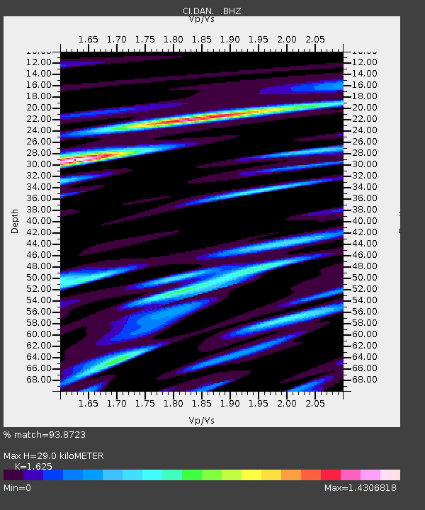
| Estimated Moho Depth: |
29.0 km |
| Estimated Crust Vp/Vs: |
1.62 |
| Assumed Crust Vp: |
6.276 km/s |
| Estimated Crust Vs: |
3.862 km/s |
| Estimated Crust Poisson's Ratio: |
0.20 |
|
| Radial Match: |
93.8723 % |
| Radial Bump: |
400 |
| Transverse Match: |
81.15205 % |
| Transverse Bump: |
400 |
| SOD ConfigId: |
356183 |
| Insert Time: |
2011-09-27 09:07:58.008 +0000 |
| GWidth: |
2.5 |
| Max Bumps: |
400 |
| Tol: |
0.001 |
|
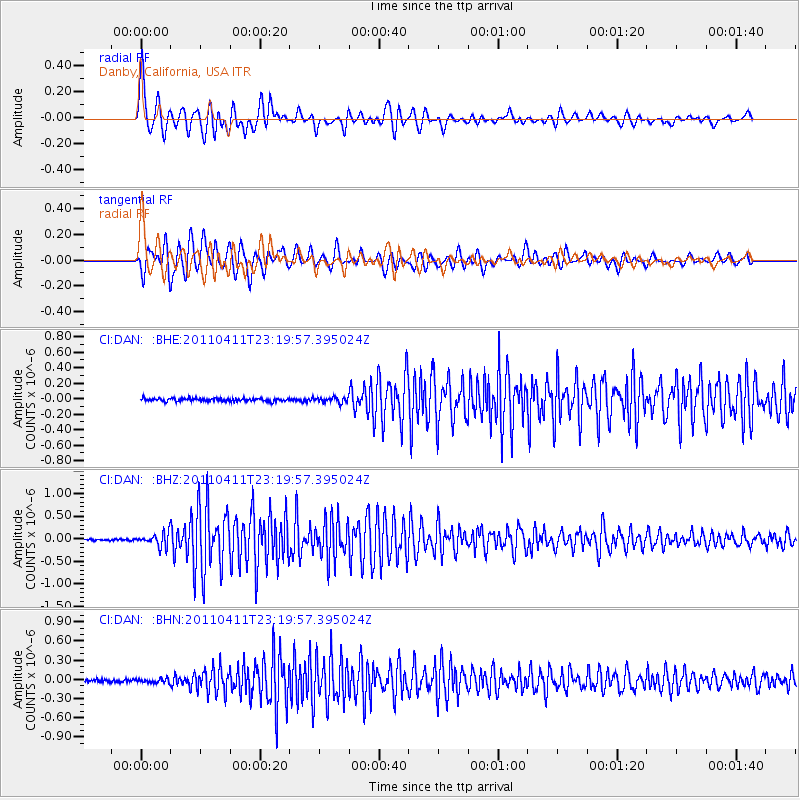
Signal To Noise
| Channel | StoN | STA | LTA |
| CI:DAN: :BHZ:20110411T23:19:57.395024Z | 9.518642 | 1.4390363E-7 | 1.5118085E-8 |
| CI:DAN: :BHN:20110411T23:19:57.395024Z | 1.7136832 | 3.2219894E-8 | 1.8801545E-8 |
| CI:DAN: :BHE:20110411T23:19:57.395024Z | 1.8044845 | 3.3852277E-8 | 1.8760081E-8 |
| Arrivals |
| Ps | 3.0 SECOND |
| PpPs | 12 SECOND |
| PsPs/PpSs | 15 SECOND |


