You are here: Home > Network List > AZ - ANZA Regional Network Stations List
> Station SMER AZ.SMER > Earthquake Result Viewer
SMER AZ.SMER - Earthquake Result Viewer
*The percent match for this event was below the threshold and hence no stack was calculated.
| Earthquake location: |
Southeast Of Loyalty Islands |
| Earthquake latitude/longitude: |
-22.5/170.8 |
| Earthquake time(UTC): |
2009/01/19 (019) 03:46:37 GMT |
| Earthquake Depth: |
35 km |
| Earthquake Magnitude: |
6.0 MW, 5.3 MB |
| Earthquake Catalog/Contributor: |
WHDF/NEIC |
|
| Network: |
AZ ANZA Regional Network |
| Station: |
SMER AZ.SMER |
| Lat/Lon: |
33.46 N/117.17 W |
| Elevation: |
355 m |
|
| Distance: |
88.3 deg |
| Az: |
52.706 deg |
| Baz: |
241.664 deg |
| Ray Param: |
$rayparam |
*The percent match for this event was below the threshold and hence was not used in the summary stack. |
|
| Radial Match: |
39.687984 % |
| Radial Bump: |
340 |
| Transverse Match: |
51.023712 % |
| Transverse Bump: |
400 |
| SOD ConfigId: |
2658 |
| Insert Time: |
2010-02-26 20:46:29.766 +0000 |
| GWidth: |
2.5 |
| Max Bumps: |
400 |
| Tol: |
0.001 |
|
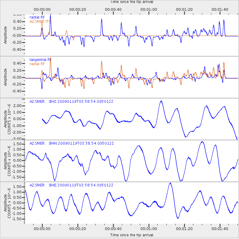
Signal To Noise
| Channel | StoN | STA | LTA |
| AZ:SMER: :BHN:20090119T03:58:54.095012Z | 0.80968964 | 3.5100226E-7 | 4.3350224E-7 |
| AZ:SMER: :BHE:20090119T03:58:54.095012Z | 0.31180653 | 2.8442938E-7 | 9.121983E-7 |
| AZ:SMER: :BHZ:20090119T03:58:54.095012Z | 1.7180058 | 1.0711979E-6 | 6.235124E-7 |
| Arrivals |
| Ps | |
| PpPs | |
| PsPs/PpSs | |


