You are here: Home > Network List > TA - USArray Transportable Network (new EarthScope stations) Stations List
> Station Q24A Divide, CO, USA > Earthquake Result Viewer
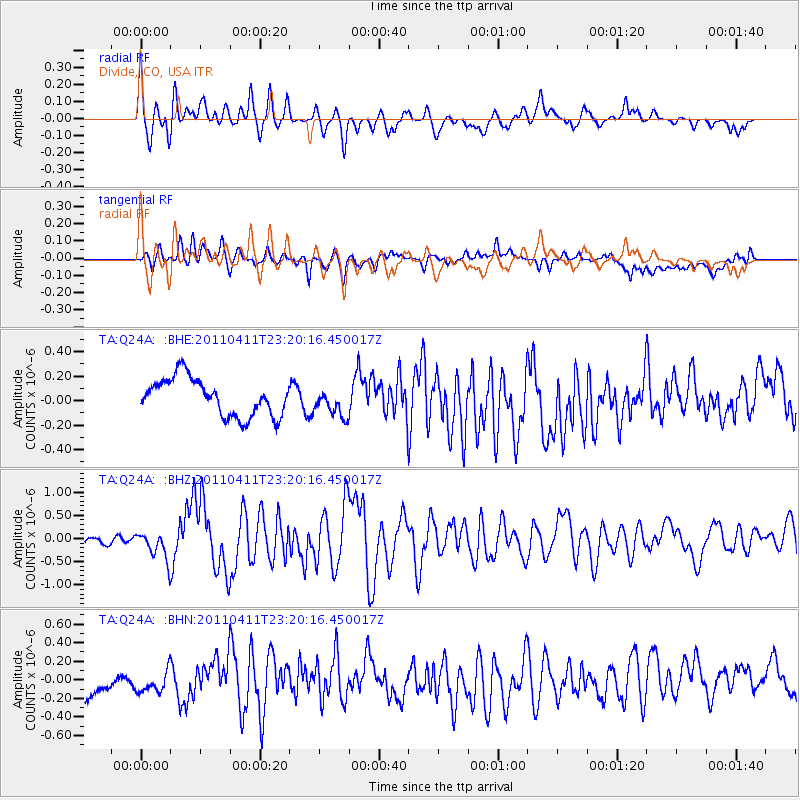
Q24A Divide, CO, USA - Earthquake Result Viewer
*The percent match for this event was below the threshold and hence no stack was calculated.
| Earthquake location: |
Near East Coast Of Honshu, Japan |
| Earthquake latitude/longitude: |
35.4/140.6 |
| Earthquake time(UTC): |
2011/04/11 (101) 23:08:16 GMT |
| Earthquake Depth: |
15 km |
| Earthquake Magnitude: |
6.0 MB, 6.1 MS, 6.2 MW, 6.2 MW |
| Earthquake Catalog/Contributor: |
WHDF/NEIC |
|
| Network: |
TA USArray Transportable Network (new EarthScope stations) |
| Station: |
Q24A Divide, CO, USA |
| Lat/Lon: |
38.96 N/105.15 W |
| Elevation: |
2775 m |
|
| Distance: |
84.3 deg |
| Az: |
45.579 deg |
| Baz: |
311.558 deg |
| Ray Param: |
$rayparam |
*The percent match for this event was below the threshold and hence was not used in the summary stack. |
|
| Radial Match: |
76.110756 % |
| Radial Bump: |
400 |
| Transverse Match: |
57.204838 % |
| Transverse Bump: |
400 |
| SOD ConfigId: |
356183 |
| Insert Time: |
2011-09-27 09:46:36.666 +0000 |
| GWidth: |
2.5 |
| Max Bumps: |
400 |
| Tol: |
0.001 |
|
Signal To Noise
| Channel | StoN | STA | LTA |
| TA:Q24A: :BHZ:20110411T23:20:16.450017Z | 2.8907297 | 2.917632E-7 | 1.0093064E-7 |
| TA:Q24A: :BHN:20110411T23:20:16.450017Z | 0.8874356 | 1.1480231E-7 | 1.293641E-7 |
| TA:Q24A: :BHE:20110411T23:20:16.450017Z | 0.7357211 | 1.1171022E-7 | 1.5183772E-7 |
| Arrivals |
| Ps | |
| PpPs | |
| PsPs/PpSs | |


