H28A Mission Ridge, SD, USA - Earthquake Result Viewer
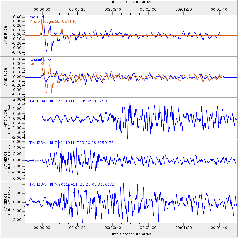
Earthquake location: Near East Coast Of Honshu, Japan
Earthquake latitude/longitude: 35.4/140.6
Earthquake time(UTC): 2011/04/11 (101) 23:08:16 GMT
Earthquake Depth: 15 km
Earthquake Magnitude: 6.0 MB, 6.1 MS, 6.2 MW, 6.2 MW
Earthquake Catalog/Contributor: WHDF/NEIC
Network: TA USArray Transportable Network (new EarthScope stations)
Station: H28A Mission Ridge, SD, USA
Lat/Lon: 44.68 N/101.02 W
Elevation: 642 m
Distance: 82.7 deg
Az: 39.249 deg
Baz: 313.587 deg
Ray Param: 0.04669585
Estimated Moho Depth: 12.0 km
Estimated Crust Vp/Vs: 1.60
Assumed Crust Vp: 6.53 km/s
Estimated Crust Vs: 4.082 km/s
Estimated Crust Poisson's Ratio: 0.18
Radial Match: 87.322914 %
Radial Bump: 366
Transverse Match: 70.67388 %
Transverse Bump: 400
SOD ConfigId: 356183
Insert Time: 2011-09-27 09:51:46.450 +0000
GWidth: 2.5
Max Bumps: 400
Tol: 0.001

Signal To Noise

ChannelStoNSTALTA
TA:H28A: :BHZ:20110411T23:20:08.325017Z8.6305778.2303256E-79.53624E-8
TA:H28A: :BHN:20110411T23:20:08.325017Z1.34058793.3475447E-72.4970723E-7
TA:H28A: :BHE:20110411T23:20:08.325017Z1.27467912.5449145E-71.996514E-7
Arrivals
Ps1.1 SECOND
PpPs4.6 SECOND
PsPs/PpSs5.8 SECOND