You are here: Home > Network List > TA - USArray Transportable Network (new EarthScope stations) Stations List
> Station H25A Fruitdale, SD, USA > Earthquake Result Viewer
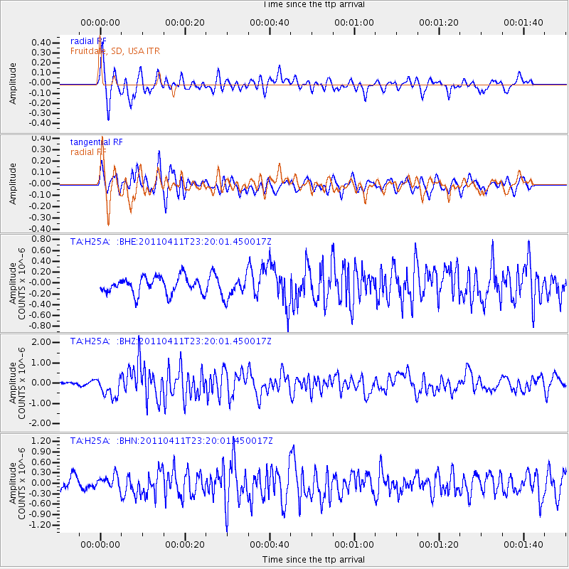
H25A Fruitdale, SD, USA - Earthquake Result Viewer
*The percent match for this event was below the threshold and hence no stack was calculated.
| Earthquake location: |
Near East Coast Of Honshu, Japan |
| Earthquake latitude/longitude: |
35.4/140.6 |
| Earthquake time(UTC): |
2011/04/11 (101) 23:08:16 GMT |
| Earthquake Depth: |
15 km |
| Earthquake Magnitude: |
6.0 MB, 6.1 MS, 6.2 MW, 6.2 MW |
| Earthquake Catalog/Contributor: |
WHDF/NEIC |
|
| Network: |
TA USArray Transportable Network (new EarthScope stations) |
| Station: |
H25A Fruitdale, SD, USA |
| Lat/Lon: |
44.62 N/103.60 W |
| Elevation: |
942 m |
|
| Distance: |
81.4 deg |
| Az: |
40.551 deg |
| Baz: |
311.962 deg |
| Ray Param: |
$rayparam |
*The percent match for this event was below the threshold and hence was not used in the summary stack. |
|
| Radial Match: |
74.63112 % |
| Radial Bump: |
400 |
| Transverse Match: |
73.1716 % |
| Transverse Bump: |
400 |
| SOD ConfigId: |
356183 |
| Insert Time: |
2011-09-27 09:53:47.838 +0000 |
| GWidth: |
2.5 |
| Max Bumps: |
400 |
| Tol: |
0.001 |
|
Signal To Noise
| Channel | StoN | STA | LTA |
| TA:H25A: :BHZ:20110411T23:20:01.450017Z | 4.739023 | 5.0369835E-7 | 1.06287374E-7 |
| TA:H25A: :BHN:20110411T23:20:01.450017Z | 0.8832965 | 1.9157672E-7 | 2.1688835E-7 |
| TA:H25A: :BHE:20110411T23:20:01.450017Z | 1.359671 | 2.0418946E-7 | 1.5017564E-7 |
| Arrivals |
| Ps | |
| PpPs | |
| PsPs/PpSs | |


