You are here: Home > Network List > AZ - ANZA Regional Network Stations List
> Station SMER AZ.SMER > Earthquake Result Viewer
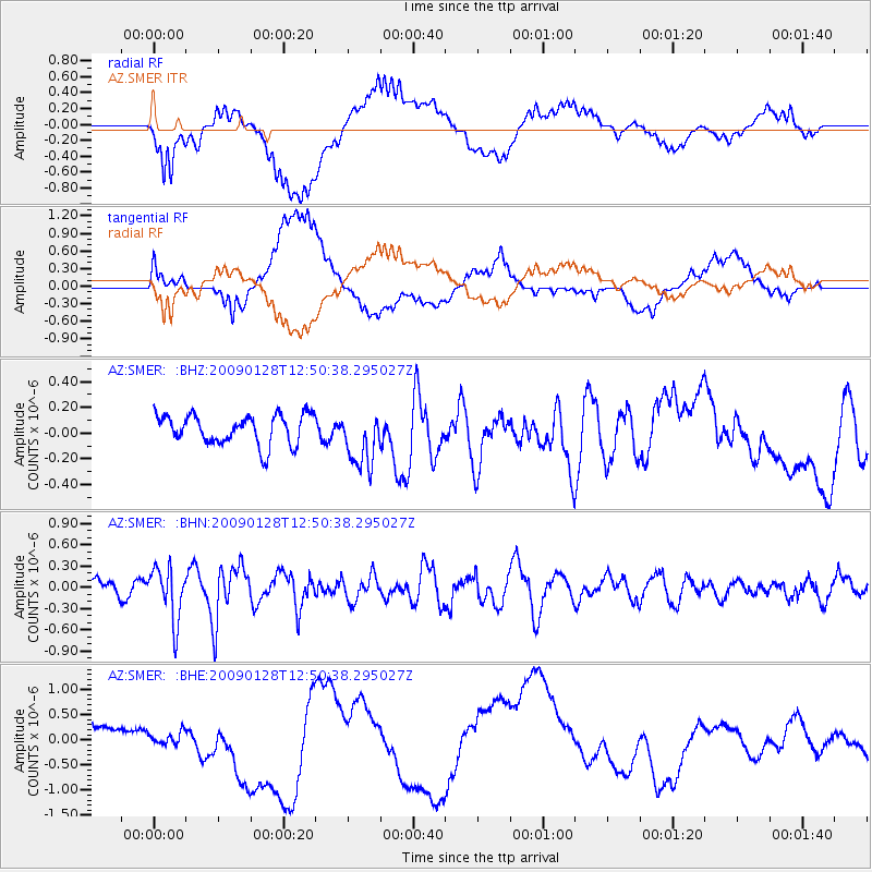
SMER AZ.SMER - Earthquake Result Viewer
*The percent match for this event was below the threshold and hence no stack was calculated.
| Earthquake location: |
Samoa Islands Region |
| Earthquake latitude/longitude: |
-17.0/-172.1 |
| Earthquake time(UTC): |
2009/01/28 (028) 12:39:42 GMT |
| Earthquake Depth: |
10 km |
| Earthquake Magnitude: |
5.6 MB, 5.3 MS, 5.5 MW |
| Earthquake Catalog/Contributor: |
WHDF/NEIC |
|
| Network: |
AZ ANZA Regional Network |
| Station: |
SMER AZ.SMER |
| Lat/Lon: |
33.46 N/117.17 W |
| Elevation: |
355 m |
|
| Distance: |
72.5 deg |
| Az: |
45.821 deg |
| Baz: |
235.181 deg |
| Ray Param: |
$rayparam |
*The percent match for this event was below the threshold and hence was not used in the summary stack. |
|
| Radial Match: |
42.56627 % |
| Radial Bump: |
400 |
| Transverse Match: |
36.554916 % |
| Transverse Bump: |
400 |
| SOD ConfigId: |
2658 |
| Insert Time: |
2010-02-26 20:46:41.253 +0000 |
| GWidth: |
2.5 |
| Max Bumps: |
400 |
| Tol: |
0.001 |
|
Signal To Noise
| Channel | StoN | STA | LTA |
| AZ:SMER: :BHN:20090128T12:50:38.295027Z | 3.611409 | 3.7402404E-7 | 1.0356735E-7 |
| AZ:SMER: :BHE:20090128T12:50:38.295027Z | 0.19927444 | 1.2096692E-7 | 6.070367E-7 |
| AZ:SMER: :BHZ:20090128T12:50:38.295027Z | 1.9095228 | 2.2122879E-7 | 1.15855535E-7 |
| Arrivals |
| Ps | |
| PpPs | |
| PsPs/PpSs | |


