You are here: Home > Network List > TA - USArray Transportable Network (new EarthScope stations) Stations List
> Station J26A Sides Ranch, Smithwick, SD, USA > Earthquake Result Viewer
J26A Sides Ranch, Smithwick, SD, USA - Earthquake Result Viewer
| Earthquake location: |
Near East Coast Of Honshu, Japan |
| Earthquake latitude/longitude: |
35.4/140.6 |
| Earthquake time(UTC): |
2011/04/11 (101) 23:08:16 GMT |
| Earthquake Depth: |
15 km |
| Earthquake Magnitude: |
6.0 MB, 6.1 MS, 6.2 MW, 6.2 MW |
| Earthquake Catalog/Contributor: |
WHDF/NEIC |
|
| Network: |
TA USArray Transportable Network (new EarthScope stations) |
| Station: |
J26A Sides Ranch, Smithwick, SD, USA |
| Lat/Lon: |
43.31 N/103.08 W |
| Elevation: |
993 m |
|
| Distance: |
82.5 deg |
| Az: |
41.274 deg |
| Baz: |
312.425 deg |
| Ray Param: |
0.046803907 |
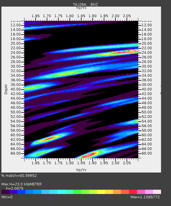
| Estimated Moho Depth: |
23.0 km |
| Estimated Crust Vp/Vs: |
2.09 |
| Assumed Crust Vp: |
6.483 km/s |
| Estimated Crust Vs: |
3.105 km/s |
| Estimated Crust Poisson's Ratio: |
0.35 |
|
| Radial Match: |
80.59952 % |
| Radial Bump: |
400 |
| Transverse Match: |
69.266495 % |
| Transverse Bump: |
368 |
| SOD ConfigId: |
356183 |
| Insert Time: |
2011-09-27 09:59:35.668 +0000 |
| GWidth: |
2.5 |
| Max Bumps: |
400 |
| Tol: |
0.001 |
|
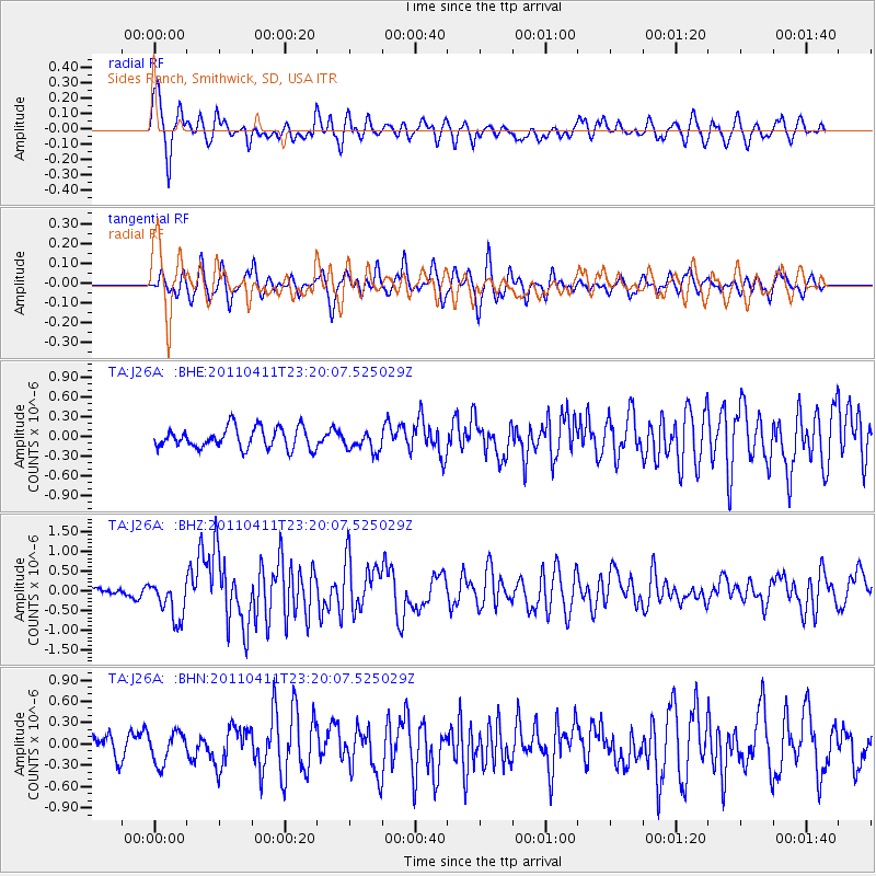
Signal To Noise
| Channel | StoN | STA | LTA |
| TA:J26A: :BHZ:20110411T23:20:07.525029Z | 5.993291 | 5.062695E-7 | 8.44727E-8 |
| TA:J26A: :BHN:20110411T23:20:07.525029Z | 1.2185078 | 2.2307636E-7 | 1.830734E-7 |
| TA:J26A: :BHE:20110411T23:20:07.525029Z | 0.954509 | 1.5132082E-7 | 1.5853263E-7 |
| Arrivals |
| Ps | 3.9 SECOND |
| PpPs | 11 SECOND |
| PsPs/PpSs | 15 SECOND |


