You are here: Home > Network List > TA - USArray Transportable Network (new EarthScope stations) Stations List
> Station B30A Myrvik Farm, Edmore, ND, USA > Earthquake Result Viewer
B30A Myrvik Farm, Edmore, ND, USA - Earthquake Result Viewer
| Earthquake location: |
Near East Coast Of Honshu, Japan |
| Earthquake latitude/longitude: |
35.4/140.6 |
| Earthquake time(UTC): |
2011/04/11 (101) 23:08:16 GMT |
| Earthquake Depth: |
15 km |
| Earthquake Magnitude: |
6.0 MB, 6.1 MS, 6.2 MW, 6.2 MW |
| Earthquake Catalog/Contributor: |
WHDF/NEIC |
|
| Network: |
TA USArray Transportable Network (new EarthScope stations) |
| Station: |
B30A Myrvik Farm, Edmore, ND, USA |
| Lat/Lon: |
48.45 N/98.33 W |
| Elevation: |
480 m |
|
| Distance: |
81.4 deg |
| Az: |
35.21 deg |
| Baz: |
314.978 deg |
| Ray Param: |
0.047608398 |
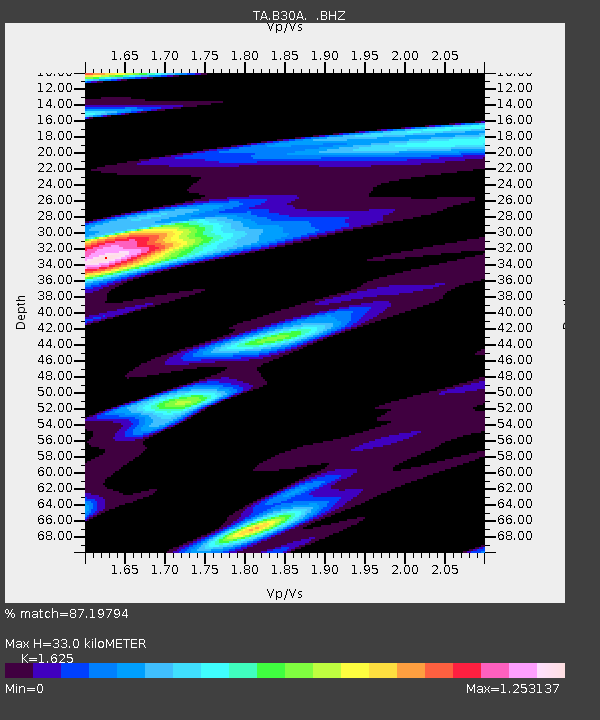
| Estimated Moho Depth: |
33.0 km |
| Estimated Crust Vp/Vs: |
1.62 |
| Assumed Crust Vp: |
6.53 km/s |
| Estimated Crust Vs: |
4.019 km/s |
| Estimated Crust Poisson's Ratio: |
0.20 |
|
| Radial Match: |
87.19794 % |
| Radial Bump: |
380 |
| Transverse Match: |
71.086426 % |
| Transverse Bump: |
400 |
| SOD ConfigId: |
356183 |
| Insert Time: |
2011-09-27 10:02:33.326 +0000 |
| GWidth: |
2.5 |
| Max Bumps: |
400 |
| Tol: |
0.001 |
|

Signal To Noise
| Channel | StoN | STA | LTA |
| TA:B30A: :BHZ:20110411T23:20:01.500005Z | 6.948031 | 6.368077E-7 | 9.165298E-8 |
| TA:B30A: :BHN:20110411T23:20:01.500005Z | 1.2887335 | 2.4503908E-7 | 1.9013946E-7 |
| TA:B30A: :BHE:20110411T23:20:01.500005Z | 1.6186788 | 3.0127117E-7 | 1.8612164E-7 |
| Arrivals |
| Ps | 3.3 SECOND |
| PpPs | 13 SECOND |
| PsPs/PpSs | 16 SECOND |


