E30A Jud, ND, USA - Earthquake Result Viewer
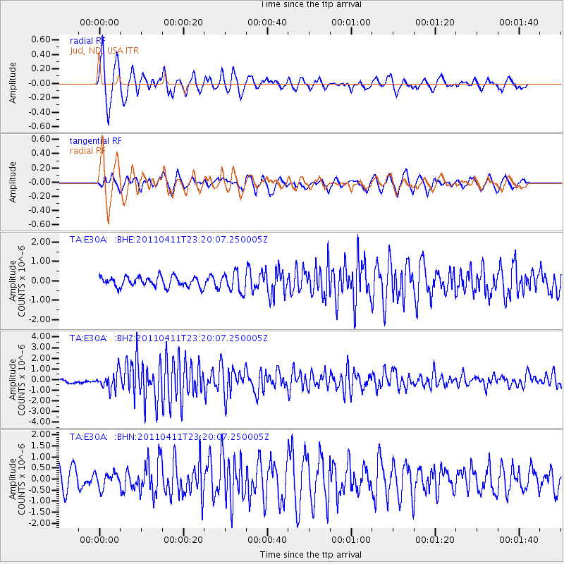
Earthquake location: Near East Coast Of Honshu, Japan
Earthquake latitude/longitude: 35.4/140.6
Earthquake time(UTC): 2011/04/11 (101) 23:08:16 GMT
Earthquake Depth: 15 km
Earthquake Magnitude: 6.0 MB, 6.1 MS, 6.2 MW, 6.2 MW
Earthquake Catalog/Contributor: WHDF/NEIC
Network: TA USArray Transportable Network (new EarthScope stations)
Station: E30A Jud, ND, USA
Lat/Lon: 46.50 N/98.91 W
Elevation: 544 m
Distance: 82.5 deg
Az: 36.887 deg
Baz: 314.786 deg
Ray Param: 0.04684212
Estimated Moho Depth: 12.25 km
Estimated Crust Vp/Vs: 1.60
Assumed Crust Vp: 6.53 km/s
Estimated Crust Vs: 4.082 km/s
Estimated Crust Poisson's Ratio: 0.18
Radial Match: 83.64895 %
Radial Bump: 362
Transverse Match: 67.80778 %
Transverse Bump: 400
SOD ConfigId: 356183
Insert Time: 2011-09-27 10:03:19.529 +0000
GWidth: 2.5
Max Bumps: 400
Tol: 0.001

Signal To Noise

ChannelStoNSTALTA
TA:E30A: :BHZ:20110411T23:20:07.250005Z4.4721618.0805887E-71.8068646E-7
TA:E30A: :BHN:20110411T23:20:07.250005Z0.838721453.431359E-74.0911786E-7
TA:E30A: :BHE:20110411T23:20:07.250005Z1.95394254.989869E-72.553744E-7
Arrivals
Ps1.2 SECOND
PpPs4.7 SECOND
PsPs/PpSs5.9 SECOND