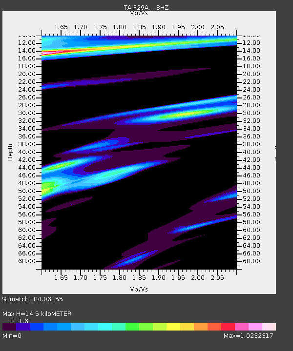
F29A Eureka, SD, USA - Earthquake Result Viewer
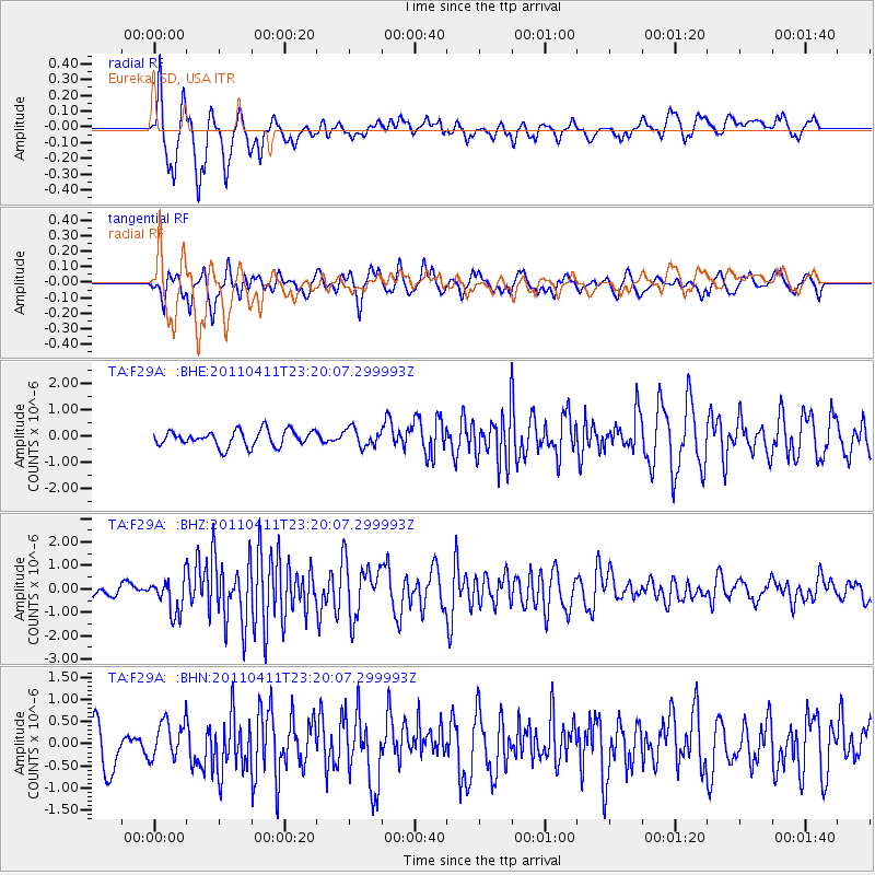
Earthquake location: Near East Coast Of Honshu, Japan
Earthquake latitude/longitude: 35.4/140.6
Earthquake time(UTC): 2011/04/11 (101) 23:08:16 GMT
Earthquake Depth: 15 km
Earthquake Magnitude: 6.0 MB, 6.1 MS, 6.2 MW, 6.2 MW
Earthquake Catalog/Contributor: WHDF/NEIC
Network: TA USArray Transportable Network (new EarthScope stations)
Station: F29A Eureka, SD, USA
Lat/Lon: 45.83 N/99.83 W
Elevation: 575 m
Distance: 82.5 deg
Az: 37.818 deg
Baz: 314.248 deg
Ray Param: 0.046832323
Estimated Moho Depth: 14.5 km
Estimated Crust Vp/Vs: 1.60
Assumed Crust Vp: 6.53 km/s
Estimated Crust Vs: 4.082 km/s
Estimated Crust Poisson's Ratio: 0.18
Radial Match: 84.06155 %
Radial Bump: 400
Transverse Match: 68.27082 %
Transverse Bump: 379
SOD ConfigId: 356183
Insert Time: 2011-09-27 10:04:10.654 +0000
GWidth: 2.5
Max Bumps: 400
Tol: 0.001

Signal To Noise

ChannelStoNSTALTA
TA:F29A: :BHZ:20110411T23:20:07.299993Z4.29846957.276872E-71.6928983E-7
TA:F29A: :BHN:20110411T23:20:07.299993Z1.12046534.222611E-73.7686226E-7
TA:F29A: :BHE:20110411T23:20:07.299993Z1.11242523.3949817E-73.0518743E-7
Arrivals
Ps1.4 SECOND
PpPs5.6 SECOND
PsPs/PpSs7.0 SECOND