You are here: Home > Network List > TA - USArray Transportable Network (new EarthScope stations) Stations List
> Station F30A Leola, SD, USA > Earthquake Result Viewer
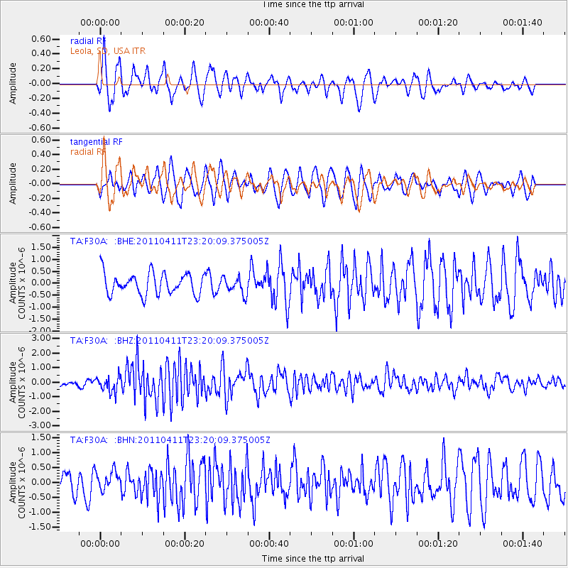
F30A Leola, SD, USA - Earthquake Result Viewer
*The percent match for this event was below the threshold and hence no stack was calculated.
| Earthquake location: |
Near East Coast Of Honshu, Japan |
| Earthquake latitude/longitude: |
35.4/140.6 |
| Earthquake time(UTC): |
2011/04/11 (101) 23:08:16 GMT |
| Earthquake Depth: |
15 km |
| Earthquake Magnitude: |
6.0 MB, 6.1 MS, 6.2 MW, 6.2 MW |
| Earthquake Catalog/Contributor: |
WHDF/NEIC |
|
| Network: |
TA USArray Transportable Network (new EarthScope stations) |
| Station: |
F30A Leola, SD, USA |
| Lat/Lon: |
45.84 N/99.03 W |
| Elevation: |
601 m |
|
| Distance: |
82.9 deg |
| Az: |
37.42 deg |
| Baz: |
314.771 deg |
| Ray Param: |
$rayparam |
*The percent match for this event was below the threshold and hence was not used in the summary stack. |
|
| Radial Match: |
71.84872 % |
| Radial Bump: |
400 |
| Transverse Match: |
68.75233 % |
| Transverse Bump: |
400 |
| SOD ConfigId: |
356183 |
| Insert Time: |
2011-09-27 10:04:36.864 +0000 |
| GWidth: |
2.5 |
| Max Bumps: |
400 |
| Tol: |
0.001 |
|
Signal To Noise
| Channel | StoN | STA | LTA |
| TA:F30A: :BHZ:20110411T23:20:09.375005Z | 3.515532 | 5.32714E-7 | 1.5153155E-7 |
| TA:F30A: :BHN:20110411T23:20:09.375005Z | 0.79833883 | 3.1131665E-7 | 3.8995552E-7 |
| TA:F30A: :BHE:20110411T23:20:09.375005Z | 0.8094294 | 3.6150354E-7 | 4.4661527E-7 |
| Arrivals |
| Ps | |
| PpPs | |
| PsPs/PpSs | |


