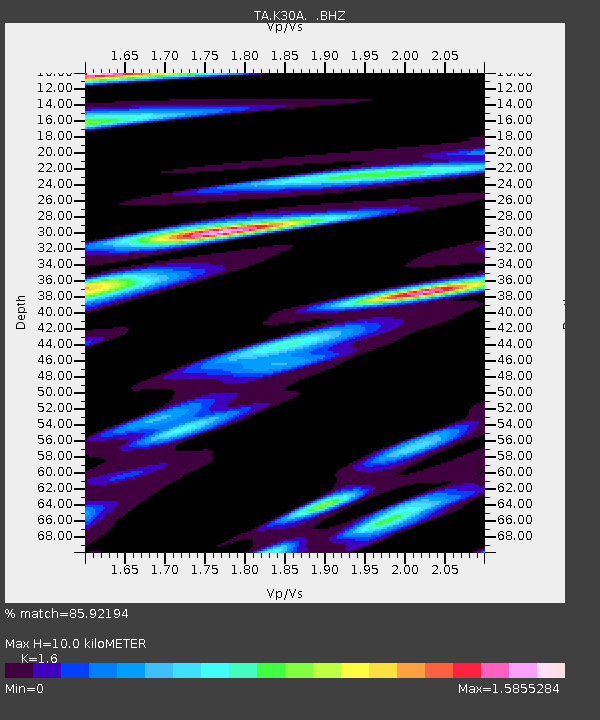
K30A Basset, NE, USA - Earthquake Result Viewer

Earthquake location: Near East Coast Of Honshu, Japan
Earthquake latitude/longitude: 35.4/140.6
Earthquake time(UTC): 2011/04/11 (101) 23:08:16 GMT
Earthquake Depth: 15 km
Earthquake Magnitude: 6.0 MB, 6.1 MS, 6.2 MW, 6.2 MW
Earthquake Catalog/Contributor: WHDF/NEIC
Network: TA USArray Transportable Network (new EarthScope stations)
Station: K30A Basset, NE, USA
Lat/Lon: 42.67 N/99.61 W
Elevation: 712 m
Distance: 84.8 deg
Az: 39.979 deg
Baz: 314.635 deg
Ray Param: 0.0451951
Estimated Moho Depth: 10.0 km
Estimated Crust Vp/Vs: 1.60
Assumed Crust Vp: 6.53 km/s
Estimated Crust Vs: 4.082 km/s
Estimated Crust Poisson's Ratio: 0.18
Radial Match: 85.92194 %
Radial Bump: 400
Transverse Match: 80.87384 %
Transverse Bump: 400
SOD ConfigId: 356183
Insert Time: 2011-09-27 10:08:30.474 +0000
GWidth: 2.5
Max Bumps: 400
Tol: 0.001

Signal To Noise

ChannelStoNSTALTA
TA:K30A: :BHZ:20110411T23:20:19.174993Z4.19753746.754446E-71.6091448E-7
TA:K30A: :BHN:20110411T23:20:19.174993Z1.42990673.2010786E-72.2386627E-7
TA:K30A: :BHE:20110411T23:20:19.174993Z1.74203113.7033587E-72.1258855E-7
Arrivals
Ps0.9 SECOND
PpPs3.9 SECOND
PsPs/PpSs4.8 SECOND