You are here: Home > Network List > AZ - ANZA Regional Network Stations List
> Station SMER AZ.SMER > Earthquake Result Viewer
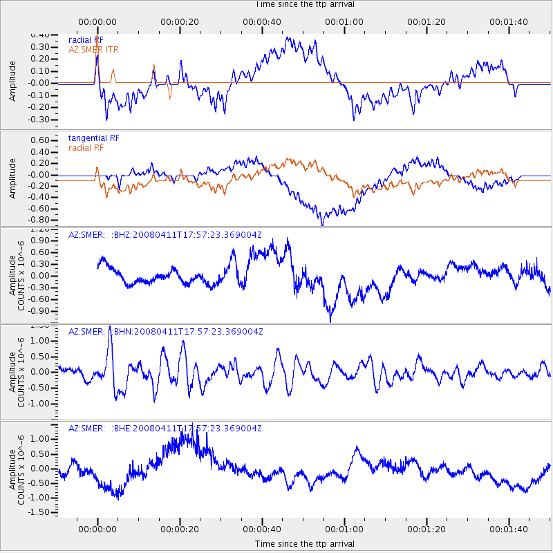
SMER AZ.SMER - Earthquake Result Viewer
*The percent match for this event was below the threshold and hence no stack was calculated.
| Earthquake location: |
Loyalty Islands |
| Earthquake latitude/longitude: |
-20.4/168.8 |
| Earthquake time(UTC): |
2008/04/11 (102) 17:45:05 GMT |
| Earthquake Depth: |
35 km |
| Earthquake Magnitude: |
5.7 MB, 5.9 MS, 6.0 MW, 6.0 MW |
| Earthquake Catalog/Contributor: |
WHDF/NEIC |
|
| Network: |
AZ ANZA Regional Network |
| Station: |
SMER AZ.SMER |
| Lat/Lon: |
33.46 N/117.17 W |
| Elevation: |
355 m |
|
| Distance: |
88.5 deg |
| Az: |
53.506 deg |
| Baz: |
244.427 deg |
| Ray Param: |
$rayparam |
*The percent match for this event was below the threshold and hence was not used in the summary stack. |
|
| Radial Match: |
39.243412 % |
| Radial Bump: |
400 |
| Transverse Match: |
43.176495 % |
| Transverse Bump: |
400 |
| SOD ConfigId: |
2504 |
| Insert Time: |
2010-02-26 20:46:43.811 +0000 |
| GWidth: |
2.5 |
| Max Bumps: |
400 |
| Tol: |
0.001 |
|
Signal To Noise
| Channel | StoN | STA | LTA |
| AZ:SMER: :BHN:20080411T17:57:23.369004Z | 3.6790822 | 6.236906E-7 | 1.6952342E-7 |
| AZ:SMER: :BHE:20080411T17:57:23.369004Z | 0.45557228 | 2.2223414E-7 | 4.878131E-7 |
| AZ:SMER: :BHZ:20080411T17:57:23.369004Z | 1.6433601 | 3.0599404E-7 | 1.8620023E-7 |
| Arrivals |
| Ps | |
| PpPs | |
| PsPs/PpSs | |


